IMAGES TAKEN NEAR TO
Corfe Road, WAREHAM, BH20 5AZ
Introduction
This page details the photographs taken nearby to Corfe Road, BH20 5AZ by members of the Geograph project.
The Geograph project started in 2005 with the aim of publishing, organising and preserving representative images for every square kilometre of Great Britain, Ireland and the Isle of Man.

There are currently over 7.5m images from over14,400 individuals and you can help contribute to the project by visiting https://www.geograph.org.uk
Image Map (Loading...)


Getting Data...Please wait
Leaflet Map data © OpenStreetMap
Images are licensed for reuse under creativecommons.org/licenses/by-sa/2.0
Notes
- Clicking on the map will re-center to the selected point.
- The higher the marker number, the further away the image location is from the centre of the postcode.
Image Listing (24 Images Found)
Images are licensed for reuse under creativecommons.org/licenses/by-sa/2.0
Image
Details
Distance
1

Lookout Holiday Park, Stoborough, Wareham, Dorset
One of the many caravan parks catering for the multitude of summer visitors to the Isle of Purbeck.
Image: © John Lamper
Taken: 19 Nov 2005
0.06 miles
2
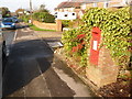
Stoborough: postbox № BH20 200, Corfe Road
This George V-reign postbox is set into an ivy-clad brick pillar and it is emptied finally at 5:15pm on weekdays and at 10:30am on Saturdays.
Image: © Chris Downer
Taken: 22 Nov 2009
0.08 miles
3
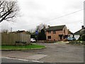
Old Furzebrook Road, Stoborough Green
Image: © Alex McGregor
Taken: 20 Jan 2012
0.08 miles
4
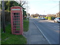
Stoborough: phone box on the Corfe Road
A traditional red phone box towards the southern end of the village.
Image: © Chris Downer
Taken: 2 Mar 2013
0.09 miles
5

Stoborough Green
Looking down the B3075, in the direction of Wareham.
Image: © Peter Trimming
Taken: 18 Apr 2015
0.09 miles
7
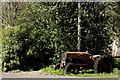
Tractor at Stoborough Green
Seen on the B3075, close to the junction with the A351.
Image: © Peter Trimming
Taken: 18 Apr 2015
0.10 miles
8
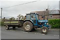
Tractor and trailer
Outside a house in Stoborough Green
Image: © Bob Harvey
Taken: 24 Nov 2015
0.11 miles
9
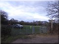
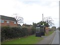
Gateway and footpath sign, Stoborough Green
The road is part of the Hardy Way, and the footpath through the gate is a local path to Melancholy Lane Image
Image: © David Smith
Taken: 26 Jan 2018
0.11 miles
10

Kissing gate, Stoborough Green
The kissing gate gives walkers access to the footpath that takes them to B3075.
Image: © Maigheach-gheal
Taken: 9 Jan 2011
0.12 miles