IMAGES TAKEN NEAR TO
West Walls, WAREHAM, BH20 4QJ
Introduction
This page details the photographs taken nearby to West Walls, BH20 4QJ by members of the Geograph project.
The Geograph project started in 2005 with the aim of publishing, organising and preserving representative images for every square kilometre of Great Britain, Ireland and the Isle of Man.

There are currently over 7.5m images from over14,400 individuals and you can help contribute to the project by visiting https://www.geograph.org.uk
Image Map
Images are licensed for reuse under creativecommons.org/licenses/by-sa/2.0
Notes
- Clicking on the map will re-center to the selected point.
- The higher the marker number, the further away the image location is from the centre of the postcode.
Image Listing (452 Images Found)
Images are licensed for reuse under creativecommons.org/licenses/by-sa/2.0
Image
Details
Distance
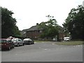
1
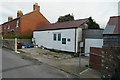
A shed by the walls
A small workshop for the Rempstone Estate, in West Walls, Wareham
Image: © Bob Harvey
Taken: 22 Nov 2015
0.01 miles
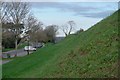
3
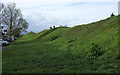
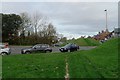
Wareham Town Walls
The west side of the walls https://historicengland.org.uk/listing/the-list/list-entry/1003574 , with a car park to the left.
Image: © Derek Harper
Taken: 4 Apr 2019
0.02 miles
4
Town walls, Wareham
The west side of the walls, with a car park to the left. The ancient monument is described at https://historicengland.org.uk/listing/the-list/list-entry/1003574 . "On the western side, where best preserved, the rampart is 3.6m high above the interior and 7.9m high above the base of the ditch." Along the top runs footpath SE2 13.
Image: © Derek Harper
Taken: 4 Apr 2019
0.02 miles
5
Wareham, Westport House
On Worgret Road; headquarters of Purbeck District Council. http://www.dorsetforyou.com/purbeck
Image: © Mike Faherty
Taken: 24 Jul 2010
0.02 miles
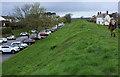
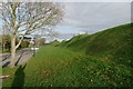
6
History on the ground
The Western Walls of Wareham were first raised in the time of Alfred the Great, but this section was repaired during another invasion scare in 1940, although they were not any higher than the 9th century originals when so finished. A thousand years does not change old England so very much.
Image: © Bob Harvey
Taken: 22 Nov 2015
0.02 miles
7
The Saxon walls
Earth banks dating back to Saxon times still surround the historic heart of Wareham
Image: © Bob Harvey
Taken: 22 Nov 2015
0.03 miles
8
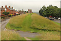
Wareham Walls
View from Bloody Bank along the west bank of Wareham town walls, part of the Saxon defensive ramparts erected in the 9th century by Alfred the Great.
Image: © Richard Croft
Taken: 10 Jul 2016
0.03 miles
9
Along the wall
Looking along the western walls from the west port
Image: © Bob Harvey
Taken: 22 Nov 2015
0.03 miles
10
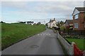
West Walls
A road inside the old Saxon earthworks, called appropriately West Walls
Image: © Bob Harvey
Taken: 22 Nov 2015
0.03 miles