IMAGES TAKEN NEAR TO
Edward Crescent, WAREHAM, BH20 4HQ
Introduction
This page details the photographs taken nearby to Edward Crescent, BH20 4HQ by members of the Geograph project.
The Geograph project started in 2005 with the aim of publishing, organising and preserving representative images for every square kilometre of Great Britain, Ireland and the Isle of Man.

There are currently over 7.5m images from over14,400 individuals and you can help contribute to the project by visiting https://www.geograph.org.uk
Image Map (Loading...)


Getting Data...Please wait
Leaflet Map data © OpenStreetMap
Images are licensed for reuse under creativecommons.org/licenses/by-sa/2.0
Notes
- Clicking on the map will re-center to the selected point.
- The higher the marker number, the further away the image location is from the centre of the postcode.
Image Listing (177 Images Found)
Images are licensed for reuse under creativecommons.org/licenses/by-sa/2.0
Image
Details
Distance
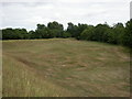
1
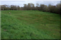
Bowling Green, Wareham
A very similar view to Image, nine years on. The trees have grown enough to obscure the houses on Edward Crescent. https://historicengland.org.uk/listing/the-list/list-entry/1003574 : http://www.wddt.org.uk/images/wareham-saxon-walls-panel-5.pdf discusses the area's possible uses.
Image: © Derek Harper
Taken: 4 Apr 2019
0.03 miles
2
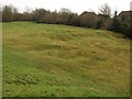
Bowling Green, Wareham
This triangular area within the northeast corner of Wareham's town walls is known as the Bowling Green, and the earthworks are probably C18, unlike the Saxon walls https://historicengland.org.uk/listing/the-list/list-entry/1003574 . Two days before this photo was taken, Purbeck District Council committed itself to spending £19000 on the next phase of the Wareham Walls Management Plan, which involves enhancing this area and clearing encroaching self-seeded trees and scrub.
Image: © Derek Harper
Taken: 21 Jan 2010
0.03 miles
3
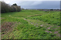
Bowling Green, Wareham
Shown from the other direction in Image http://www.wddt.org.uk/images/wareham-saxon-walls-panel-5.pdf
Image: © Derek Harper
Taken: 4 Apr 2019
0.04 miles
4
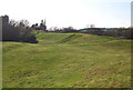
Lumps & bumps of the town walls.
The remains of the Anglo-Saxon walls of Wareham.
Image: © N Chadwick
Taken: 8 Apr 2008
0.05 miles
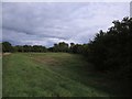
5
Wareham, open ground
In the north-eastern corner of the town walls. Unevenness probably caused by gravel or sand extraction; the bright green area was once a bowling green.
Image: © Mike Faherty
Taken: 24 Jul 2010
0.05 miles
6
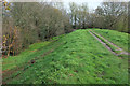
Town walls, Wareham
At the northeast edge of the town, with the Saxon rampart enclosing the bowling green on the right https://historicengland.org.uk/listing/the-list/list-entry/1003574 . This is footpath SE2 14#1.
Image: © Derek Harper
Taken: 4 Apr 2019
0.05 miles
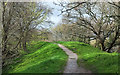
7
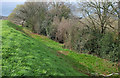
Town walls, Wareham
The eastern side of the northeast corner, which is access land. The path along the top is the Poole Harbour Trail following footpath SE2 14#1.
Image: © Derek Harper
Taken: 4 Apr 2019
0.06 miles
9
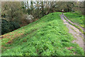
Poole Harbour Trail on Wareham Town Walls
Footpath SE2 14#1 curves to head down the eastern edge of the town along the Saxon ramparts. https://historicengland.org.uk/listing/the-list/list-entry/1003574 .
Image: © Derek Harper
Taken: 4 Apr 2019
0.06 miles
10
Town walls, Wareham
Looking in the opposite direction from where Image] was taken, approaching the Bowling Green. https://historicengland.org.uk/listing/the-list/list-entry/1003574
Image: © Derek Harper
Taken: 4 Apr 2019
0.07 miles