IMAGES TAKEN NEAR TO
St. Marys Close, WAREHAM, BH20 4BU
Introduction
This page details the photographs taken nearby to St. Marys Close, BH20 4BU by members of the Geograph project.
The Geograph project started in 2005 with the aim of publishing, organising and preserving representative images for every square kilometre of Great Britain, Ireland and the Isle of Man.

There are currently over 7.5m images from over14,400 individuals and you can help contribute to the project by visiting https://www.geograph.org.uk
Image Map (Loading...)


Getting Data...Please wait
Leaflet Map data © OpenStreetMap
Images are licensed for reuse under creativecommons.org/licenses/by-sa/2.0
Notes
- Clicking on the map will re-center to the selected point.
- The higher the marker number, the further away the image location is from the centre of the postcode.
Image Listing (14 Images Found)
Images are licensed for reuse under creativecommons.org/licenses/by-sa/2.0
Image
Details
Distance
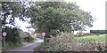
1
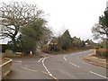
Carey Road, Wareham
The road bends to the right at this junction with Wessex Oval and a track to Ferncroft Farm. Immediately to the left of the camera is the start of footpath SE2/5.
Image: © Derek Harper
Taken: 21 Jan 2010
0.04 miles
2
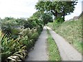
Wareham, Humber Chase
Lane running through suburban developments from Carey Road to Ferncroft Farm.
Image: © Mike Faherty
Taken: 10 Oct 2016
0.06 miles
3
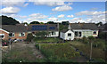
Bungalows and back gardens, Wareham
In the southwest of the town, in West Mill Crescent and Walls View Road. The view is from a Weymouth-Waterloo train approaching Wareham.
Image: © Robin Stott
Taken: 15 Aug 2017
0.13 miles
4
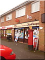
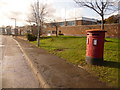
Wareham: Carey Estate Post Office and postbox № BH20 267
This sub-post office, named Carey Estate and positioned in a short row of shops, serves the northern half of Wareham, which is rather detached from the main town by the railway. The George V-reign postbox, with a post office direction sign on its top, is emptied finally at 5:30pm on weekdays and at 12:30pm on Saturdays.
Image: © Chris Downer
Taken: 22 Nov 2009
0.15 miles
5
Wareham - Carey area
Entering Carey from Trigon direction
Image: © Peter Elsdon
Taken: 6 Nov 2009
0.17 miles
6
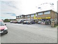
Northport, post office
Carey Road Post Office, in a Premier convenience store.
Image: © Mike Faherty
Taken: 10 Oct 2016
0.17 miles
7
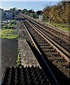
Railway from Wareham towards Wool, Dorset
Looking to the WSW from Wareham station.
Image: © Jaggery
Taken: 12 Nov 2022
0.21 miles
8
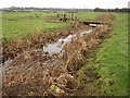
Drainage channel near the Piddle
From footpath SE2/5, which swings across the grassy footbridge as it traverses the Piddle flood plain.
Image: © Derek Harper
Taken: 21 Jan 2010
0.21 miles
9
Wareham: postbox № BH20 98, Westminster Road
A large, double-aperture postbox serving this industrial estate road, emptied finally at 6pm on weekdays and at 12:30pm on Saturdays.
Image: © Chris Downer
Taken: 22 Nov 2009
0.23 miles
10
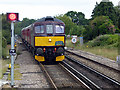
A train from Swanage approaching Wareham station
2017 is the first year of through timetabled services between the two towns since the line closed to passengers in 1972. The train consists of 4 carriages 'topped and tailed' by 2 class 33 locomotives. Swanage Railway has a diesel multiple unit currently being overhauled to provide the service.
Image: © John Lucas
Taken: 12 Jul 2017
0.23 miles