IMAGES TAKEN NEAR TO
North Street, WAREHAM, BH20 4AE
Introduction
This page details the photographs taken nearby to North Street, BH20 4AE by members of the Geograph project.
The Geograph project started in 2005 with the aim of publishing, organising and preserving representative images for every square kilometre of Great Britain, Ireland and the Isle of Man.

There are currently over 7.5m images from over14,400 individuals and you can help contribute to the project by visiting https://www.geograph.org.uk
Image Map (Loading...)


Getting Data...Please wait
Leaflet Map data © OpenStreetMap
Images are licensed for reuse under creativecommons.org/licenses/by-sa/2.0
Notes
- Clicking on the map will re-center to the selected point.
- The higher the marker number, the further away the image location is from the centre of the postcode.
Image Listing (212 Images Found)
Images are licensed for reuse under creativecommons.org/licenses/by-sa/2.0
Image
Details
Distance
1
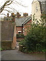
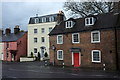
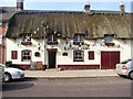
Mount Pleasant, Wareham
Mount Pleasant drops narrowly to meet North Street at the north end of the town. The houses on either side of this street are listed; on the left is the former Lord Nelson pub https://historicengland.org.uk/listing/the-list/list-entry/1119994 , and on the right, the stucco 54 North Street https://historicengland.org.uk/listing/the-list/list-entry/1304412 .
Image: © Derek Harper
Taken: 21 Jan 2010
0.01 miles
2
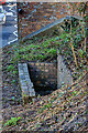
Defending Dorset in 1940: the Maiden Newton - Poole Harbour Stop Line (83)
-
Pillbox (variant): DoB ID: S0008510
Wareham - St Martin's Church - Square Variant Pillbox. A view looking down on the entrance to the pillbox in the NW corner of the churchyard showing it in context with North Street.
Image
Image: © Mike Searle
Taken: 24 Feb 2016
0.02 miles
3
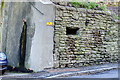
Defending Dorset in 1940: the Maiden Newton - Poole Harbour Stop Line (84)
-
Pillbox (variant): DoB ID: S0008510
Wareham -St Martin's Church - Square Variant Pillbox. A closer view of this pillbox built into the wall of St Martin's churchyard. The outline of the blocked embrasure in the end wall can be seen to the right of the drainpipe's water stain. Both the railway and the River Frome on their route east along the Stop Line from Maiden Newton towards Poole, part company here. The Frome flows east into Poole Harbour, whilst the railway swings away to the north on its short journey around the harbour to Poole town.
Image
Image: © Mike Searle
Taken: 18 Feb 2016
0.02 miles
4
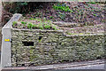
Defending Dorset in 1940: the Maiden Newton - Poole Harbour Stop Line (85)
-
Pillbox (variant): DoB ID: S0008510
Wareham -St Martin's Church - Square Variant Pillbox. Another close view of both the pillbox and its brick entrance in the churchyard above. No doubt any objections raised at the time about building the pillbox in the churchyard would have been overruled by wartime expediency.
Image
Image: © Mike Searle
Taken: 24 Feb 2016
0.02 miles
5
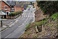
Listed buildings, Wareham
On the B3075 North Street, here followed by the Hardy Way. On the right is the former Lord Nelson pub https://historicengland.org.uk/listing/the-list/list-entry/1119994 , and beyond it, the stucco 54 North Street https://historicengland.org.uk/listing/the-list/list-entry/1304412 . Between them is the narrow Mount Pleasant Image
Image: © Derek Harper
Taken: 4 Apr 2019
0.02 miles
6
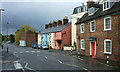
North Street, Wareham
Looking more to the left than Image], with the former Lord Nelson pub https://historicengland.org.uk/listing/the-list/list-entry/1119994 on the right. Past the terrace of five and just before North Bridge is the building shown in Image
Image: © Derek Harper
Taken: 4 Apr 2019
0.02 miles
7
Defending Dorset in 1940: the Maiden Newton - Poole Harbour Stop Line (82)
-
Pillbox (variant): DoB ID: S0008510
Wareham - St Martin's Church - Square Variant Pillbox. The brick-built entrance to the pillbox in the NW corner of St Martin's churchyard.
Image
Image: © Mike Searle
Taken: 18 Feb 2016
0.02 miles
8
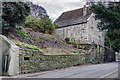
Defending Dorset in 1940: the Maiden Newton - Poole Harbour Stop Line (81)
-
Pillbox (variant): DoB ID: S0008510
Wareham - St Martin's Church - Square Variant Pillbox. Looking very much like a simple loopholed wall, this is in fact a complete pillbox that was disguised by building into the wall of the NW corner of St Martin's churchyard. Square in outline, it had two embrasures, one is extant, the other on the north side wall has been rendered over, whilst inside under each one is a concrete shelf. As can be seen it is well camouflaged, the stonework having been chosen to blend with that of the churchyard wall. The brick entrance passage in the churchyard is via steps down between two blast walls to an entrance doorway on the left. Situated just north of the Frome, it was built to cover the northern approach to the town, the Piddle Valley, and the railway to Poole.
Image
Image: © Mike Searle
Taken: 24 Feb 2016
0.02 miles
9
King's Arms, Wareham
It is located at North-Street
Image: © Kenneth Allen
Taken: 20 Sep 2003
0.03 miles
10
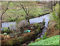
River Piddle at Wareham
The mill race rejoins the river just below the North Mill.
Image: © Derek Harper
Taken: 4 Apr 2019
0.03 miles