IMAGES TAKEN NEAR TO
Boundary Close, SWANAGE, BH19 2JY
Introduction
This page details the photographs taken nearby to Boundary Close, BH19 2JY by members of the Geograph project.
The Geograph project started in 2005 with the aim of publishing, organising and preserving representative images for every square kilometre of Great Britain, Ireland and the Isle of Man.

There are currently over 7.5m images from over14,400 individuals and you can help contribute to the project by visiting https://www.geograph.org.uk
Image Map (Loading...)


Getting Data...Please wait
Leaflet Map data © OpenStreetMap
Images are licensed for reuse under creativecommons.org/licenses/by-sa/2.0
Notes
- Clicking on the map will re-center to the selected point.
- The higher the marker number, the further away the image location is from the centre of the postcode.
Image Listing (40 Images Found)
Images are licensed for reuse under creativecommons.org/licenses/by-sa/2.0
Image
Details
Distance
1
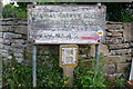
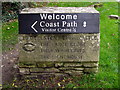
Old footpath sign
Difficult to read because of faded paint. This path does not appear on the 1:50000 but does on the 1:25000. Situated just off the road from Swanage to Durlston Country Park there is another similar sign a few hundred metres away at the end of this small straight section of path.
Image: © Nigel Mykura
Taken: 10 May 2008
0.07 miles
2
Private property notice at Durlston Country Park
Dating from 1878, when George Burt was developing the Durlston estate as a tourist attraction. This is now beside a public footpath entering woodland in Durlston Country Park.
Image: © Phil Champion
Taken: 22 Sep 2009
0.08 miles
5

Suburban laburnum
On a quiet back street on the edge of Swanage close to Durlston Country Park
Image: © Nigel Mykura
Taken: 10 May 2008
0.09 miles
6
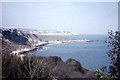
Durlston Bay from Durlston Castle
Looking almost directly northwards.
Image: © John Lucas
Taken: 14 Apr 1968
0.09 miles
7
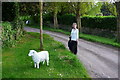
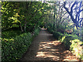
Two Lambs
The surname of the woman in the picture just happens to be Lamb. The plastic one got there presumably with the help of a local resident of this quiet footpath lane near Durlston Country Park near Swanage.
Image: © Nigel Mykura
Taken: 10 May 2008
0.09 miles
8
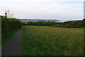
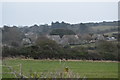
View Towards Peveril Point from Durlston
Taken from the path down into Swanage from the Country Park
Image: © Nigel Mykura
Taken: 10 May 2008
0.10 miles
9
Signs to Durlston
This new and old sign both point down a track which joins with the 'Isle of Wight Road', a walled track along the top of the cliffs in Durlston Bay. A landslip in Durlston Bay has made necessary this slight inland detour of the coast path. The Large Globe and Light House can still be visited. It has not been possible to go into Tilly Whim caves since they were shut to the public in 1976. The Head is still there and the Castle is being refurbished as a Jurassic Coast visitor centre.
Image: © Jim Champion
Taken: 27 Oct 2008
0.10 miles
10
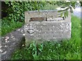
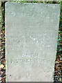
Guidestone, Durlston Road, Swanage
Carved stone guide post in the Parish of Swanage (Purbeck District) on Durlston Road, Swanage, at entrance to park in pillar, East side of road. Erected for local entrepreneur George Burt as part of his abortive scheme to develop the area; late C19.
Inscription reads:- : TO DURLSTON HEAD AND CASTLE / {hand to left} THE LARGE GLOBE / TILLY WHIM CAVES / AND THE LIGHT HOUSE :
Milestone Society National ID: DO_DHLI04.
Image: © Milestone Society
Taken: 31 May 2017
0.11 miles