IMAGES TAKEN NEAR TO
Sundew Road, BROADSTONE, BH18 9NX
Introduction
This page details the photographs taken nearby to Sundew Road, BH18 9NX by members of the Geograph project.
The Geograph project started in 2005 with the aim of publishing, organising and preserving representative images for every square kilometre of Great Britain, Ireland and the Isle of Man.

There are currently over 7.5m images from over14,400 individuals and you can help contribute to the project by visiting https://www.geograph.org.uk
Image Map
Images are licensed for reuse under creativecommons.org/licenses/by-sa/2.0
Notes
- Clicking on the map will re-center to the selected point.
- The higher the marker number, the further away the image location is from the centre of the postcode.
Image Listing (10 Images Found)
Images are licensed for reuse under creativecommons.org/licenses/by-sa/2.0
Image
Details
Distance
1
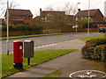
Broadstone: postbox № BH18 286, Pinesprings Drive
A modern postbox serving a modern housing estate, emptied finally at 4:15pm on weekdays and at 11:45am on Saturdays. Alongside is a drop box (see below).
Image: © Chris Downer
Taken: 2 Apr 2010
0.08 miles
2
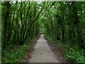
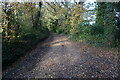
Pinesprings, railway trackbed
Once the Southampton to Dorchester railway, nicknamed "Castleman Corkscrew" because of its sinuous route; now the Castleman Trailway: http://www.dorsetforyou.com/castlemantrailway
Image: © Mike Faherty
Taken: 22 Jun 2011
0.13 miles
3
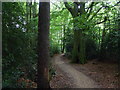
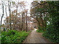
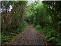
Pinesprings LNR
A local nature reserve on both sides of Pinesprings Drive. This part, to the East,is sandwiched between suburban housing, but contains large oak, beech and sweet chestnut trees, with conifers.
Image: © Mike Faherty
Taken: 22 Jun 2011
0.15 miles
4
Pinesprings, Chaffinch Close
Side road off Beechbank Avenue; like most other roads on this part of the estate, named after native wild birds.
Image: © Mike Faherty
Taken: 22 Jun 2011
0.16 miles
5
Upton Heath, fire damage
Scorched tree foliage on Roman Road after a devastating arson attack on the heath. The road appears to have acted as fire break, preventing damage further East. http://www.bbc.co.uk/news/uk-england-dorset-13738315
Image: © Mike Faherty
Taken: 22 Jun 2011
0.19 miles
6
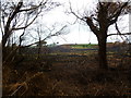
Upton Heath, site of fire
The eastern edge of Upton Heath. A large area of heathland was devastated after an arson attach two weeks ago: http://www.bbc.co.uk/news/uk-england-dorset-13738315
Image: © Mike Faherty
Taken: 22 Jun 2011
0.20 miles
7
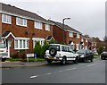
Chaffinch Close, Broadstone
All the streets in this very suburban part of Poole are named after common birds.
Image: © Nigel Mykura
Taken: 22 Nov 2009
0.20 miles
8
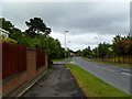
Pinesprings Drive
A suburban road connecting Roman Road and Beechbank Avenue, and serving housing closes.
Image: © Mike Faherty
Taken: 22 Jun 2011
0.21 miles
9
Turf Zone "RomanTrail"
On Upton Heath Nature Reserve.
Image: © Ian S
Taken: 17 Nov 2022
0.22 miles
10
Pinesprings, Roman road
Once the Roman Road from Lake (by Hamworthy) to Badbury; this section is now a bridleway, joining Roman Road to the North. The road also forms the boundary between East Dorset (to the left) and Poole (right).
Image: © Mike Faherty
Taken: 22 Jun 2011
0.24 miles