IMAGES TAKEN NEAR TO
Corfe Lodge Road, BROADSTONE, BH18 9NG
Introduction
This page details the photographs taken nearby to Corfe Lodge Road, BH18 9NG by members of the Geograph project.
The Geograph project started in 2005 with the aim of publishing, organising and preserving representative images for every square kilometre of Great Britain, Ireland and the Isle of Man.

There are currently over 7.5m images from over14,400 individuals and you can help contribute to the project by visiting https://www.geograph.org.uk
Image Map (Loading...)


Getting Data...Please wait
Leaflet Map data © OpenStreetMap
Images are licensed for reuse under creativecommons.org/licenses/by-sa/2.0
Notes
- Clicking on the map will re-center to the selected point.
- The higher the marker number, the further away the image location is from the centre of the postcode.
Image Listing (13 Images Found)
Images are licensed for reuse under creativecommons.org/licenses/by-sa/2.0
Image
Details
Distance
1
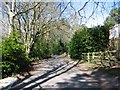
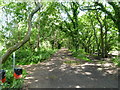
Corfe Lodge Road
A rough road, recently tarmaced. On the right is Stonecrop Wood, only two acres, once part of someone's garden, became overun with laurel and rhododendron, and tall thin maritime pines fighting for light. Now surrounded by buildings. Now looked after by the Woodland Trust.
Image: © John Palmer
Taken: 30 Mar 2009
0.02 miles
2
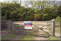
Fire access at Upton Heath Nature Reserve
Heathland is at constant threat from fire during dry conditions. Heath fires are unfortunately a regular occurrence and many arise suspiciously during school holidays. The resulting devastation of the habitat of rare species in these areas of Dorset puts their survival at risk.
Image: © John Lamper
Taken: 4 May 2006
0.05 miles
3
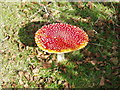
Fly Agaric
Fly Agaric fungus on the heath in autumn sunshine
Image: © David Tarrant
Taken: 9 Oct 2008
0.10 miles
4
Turf Zone "LesleysHeath"
At Lesley's Heath, Corfe Mullen.
Image: © Ian S
Taken: 17 Nov 2022
0.11 miles
5
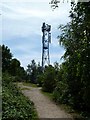
Upton Heath, phone mast
Overlooking the heath with a reservoir to the left; operated by Vodafone.
Image: © Mike Faherty
Taken: 14 Jun 2011
0.13 miles
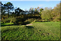
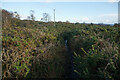
6
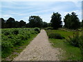
Upton Heath, footpath
From the car park to the view point, across access land.
Image: © Mike Faherty
Taken: 14 Jun 2011
0.13 miles
7
Hill View, Corfe Mullen
The sign marks the beginning of Dorset Wildlife Trust’s nature reserve on Upton Heath
http://www.wildlifetrust.org.uk/dorset/reserves/upton.htm
Image: © John Lamper
Taken: 4 May 2006
0.13 miles
8
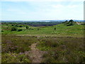
Upton Heath, view
Looking down from near the viewpoint towards sloping heathland. In the distance, the black scar is burnt heathland after a devastating arson attack last week; in the far distance, Poole and Poole Harbour.
Image: © Mike Faherty
Taken: 14 Jun 2011
0.13 miles
9
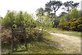
Hillview, Corfe Lodge Road
Private road from Wareham Road to Roman Road.
Image: © Mike Faherty
Taken: 14 Jun 2011
0.15 miles
10
Turf Zone "Maxwell"
On Upton Heath Nature Reserve.
Image: © Ian S
Taken: 17 Nov 2022
0.16 miles