IMAGES TAKEN NEAR TO
West Way, BROADSTONE, BH18 9LP
Introduction
This page details the photographs taken nearby to West Way, BH18 9LP by members of the Geograph project.
The Geograph project started in 2005 with the aim of publishing, organising and preserving representative images for every square kilometre of Great Britain, Ireland and the Isle of Man.

There are currently over 7.5m images from over14,400 individuals and you can help contribute to the project by visiting https://www.geograph.org.uk
Image Map (Loading...)


Getting Data...Please wait
Leaflet Map data © OpenStreetMap
Images are licensed for reuse under creativecommons.org/licenses/by-sa/2.0
Notes
- Clicking on the map will re-center to the selected point.
- The higher the marker number, the further away the image location is from the centre of the postcode.
Image Listing (51 Images Found)
Images are licensed for reuse under creativecommons.org/licenses/by-sa/2.0
Image
Details
Distance
1
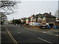
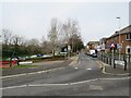
Clarendon Road, Broadstone
Clarendon Road is a residential road in Broadstone, a suburb of Poole.
Image: © Malc McDonald
Taken: 7 Feb 2022
0.06 miles
2
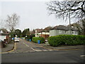
Clarendon Close, Broadstone
Clarendon Close is a residential cul-de-sac in Broadstone, on the outskirts of Poole.
Image: © Malc McDonald
Taken: 7 Feb 2022
0.06 miles
3
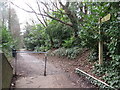
Castleman Trailway, Broadstone, near Poole
This shared path for walking and cycling follows the route of a dismantled railway through Broadstone. It forms part of the Castleman Trailway.
Image: © Malc McDonald
Taken: 7 Feb 2022
0.07 miles
4
Broadstone: postbox № BH18 167, Ascot Road
Looking along the southern section of Ascot Road past this Elizabeth II-reign postbox, which is leaning backwards slightly and is emptied finally at 5:30pm on weekdays and at 11:45am on Saturdays.
Image: © Chris Downer
Taken: 12 Jul 2009
0.08 miles
5
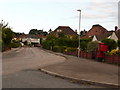
Station Approach, Broadstone
Station Approach in Broadstone, on the outskirts of Poole.
The railway station closed in 1966. It occupied the site to the left of the road.
Image: © Malc McDonald
Taken: 7 Feb 2022
0.13 miles
6
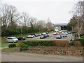
Broadstone leisure centre and car park
Broadstone's leisure centre is built on the site of Broadstone railway station, which closed in 1966.
Image: © Malc McDonald
Taken: 7 Feb 2022
0.13 miles
7
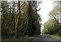
Heading north on Broadstone Way
This road is built on the trackbed of the former LSWR between Holes Bay and Broadstone. On the left, at a slightly higher level, is the trackbed of the disused railway from Broadstone to Hamworthy.
Image: © Peter Kazmierczak
Taken: 29 Feb 2016
0.13 miles
8
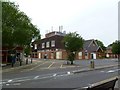
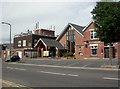
Broadstone Telephone Exchange
At the corner of Broadway and Macauley Road.
Image: © Mike Faherty
Taken: 29 May 2011
0.13 miles
9
Broadstone, Methodist Church Centre
On The Broadway. http://www.broadstonemethodist.org.uk/
Image: © Mike Faherty
Taken: 11 Jul 2010
0.14 miles
10
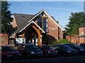
Broadstone: the Methodist church
A large, modern building towards the north end of Image
Image: © Chris Downer
Taken: 17 Jun 2014
0.14 miles