IMAGES TAKEN NEAR TO
Fairview Road, BROADSTONE, BH18 9AU
Introduction
This page details the photographs taken nearby to Fairview Road, BH18 9AU by members of the Geograph project.
The Geograph project started in 2005 with the aim of publishing, organising and preserving representative images for every square kilometre of Great Britain, Ireland and the Isle of Man.

There are currently over 7.5m images from over14,400 individuals and you can help contribute to the project by visiting https://www.geograph.org.uk
Image Map
Images are licensed for reuse under creativecommons.org/licenses/by-sa/2.0
Notes
- Clicking on the map will re-center to the selected point.
- The higher the marker number, the further away the image location is from the centre of the postcode.
Image Listing (24 Images Found)
Images are licensed for reuse under creativecommons.org/licenses/by-sa/2.0
Image
Details
Distance
1
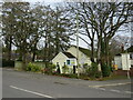
Christadelphian Hall, Broadstone
A Christadelphian hall in Broadstone, in the outskirts of Poole.
Image: © Malc McDonald
Taken: 7 Feb 2022
0.09 miles
2
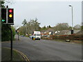
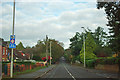
Higher Blandford Road, Broadstone, near Poole
A traffic light-controlled junction on Higher Blandford Road in Broadstone, on the outskirts of Poole. This road forms part of the route of the B3074.
Image: © Malc McDonald
Taken: 7 Feb 2022
0.10 miles
3
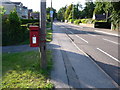
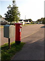
Broadstone: postbox № BH18 43, Higher Blandford Road
Lower and Higher Blandford Road between them form a long, largely straight road which does indeed head towards Blandford from Poole (though nowadays traffic is directed along the A350). Here we look up a particularly straight stretch past this postbox, which hugs a telephone pole and is emptied finally at 5:30pm on weekdays and at 11:45am on Saturdays.
Image: © Chris Downer
Taken: 12 Jul 2009
0.11 miles
4
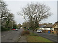
Higher Blandford Road, Broadstone, near Poole
Higher Blandford Road heading out of Broadstone, near Poole. The road forms part of the route of the B3074.
This image was taken on a February day. Most of the trees were bare for the winter months.
Image: © Malc McDonald
Taken: 7 Feb 2022
0.12 miles
5
Broadstone: postbox № BH18 128, Fairview Road
This Elizabeth II-reign postbox serves this small estate of bungalows off the Higher Blandford Road, and is emptied finally at 5:30pm on weekdays and at 11:45am on Saturdays.
Image: © Chris Downer
Taken: 12 Jul 2009
0.13 miles
6
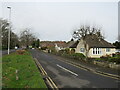
Upper Blandford Road
A road of long straights.
Image: © Robin Webster
Taken: 30 Oct 2012
0.14 miles
7
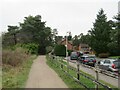
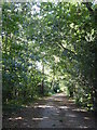
Castleman Trailway, Broadstone
A view of the Castleman Trailway heading north out of Broadstone. This section of the path is also on route 25 of the National Cycle Network.
This is the site of a railway junction just to the north of Broadstone station. The path curving off to the left is on the trackbed of the former Somerset & Dorset Joint Railway, which closed in 1966. The road and houses to the right occupy the trackbed of the former line to Wimborne which closed in 1964. These closures were part of the "Beeching Cuts".
A short distance further on from where this image was taken, the Castleman Trailway will leave the route of the Somerset & Dorset line and cross over to take up the route towards Wimborne.
Image: © Malc McDonald
Taken: 30 Dec 2024
0.14 miles
8
Higher Blandford Road, Broadstone, near Poole
Higher Blandford Road forms part of the B3074 road passing through Broadstone, a suburb of Poole. Here, there is a parallel side road in front of the houses.
Image: © Malc McDonald
Taken: 7 Feb 2022
0.15 miles
9
Path on the course of the former railway at Broadstone
A popular route for runners.
Image: © Rod Allday
Taken: 21 Sep 2018
0.15 miles
10
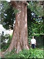
Broadstone's Giant Sequoia
Planted by a Miss Cotton in the garden of Home Cottage, 73 Higher Blandford Road, this huge tree is now 560 cms in girth. Discovered in California and only introduced to Europe in 1953, this tree will grow a lot bigger and be visible for miles. It must be Broadstone's largest tree.
Image: © John Palmer
Taken: 7 Jul 2010
0.16 miles