IMAGES TAKEN NEAR TO
Woods Edge, BROADSTONE, BH18 8EH
Introduction
This page details the photographs taken nearby to Woods Edge, BH18 8EH by members of the Geograph project.
The Geograph project started in 2005 with the aim of publishing, organising and preserving representative images for every square kilometre of Great Britain, Ireland and the Isle of Man.

There are currently over 7.5m images from over14,400 individuals and you can help contribute to the project by visiting https://www.geograph.org.uk
Image Map (Loading...)


Getting Data...Please wait
Leaflet Map data © OpenStreetMap
Images are licensed for reuse under creativecommons.org/licenses/by-sa/2.0
Notes
- Clicking on the map will re-center to the selected point.
- The higher the marker number, the further away the image location is from the centre of the postcode.
Image Listing (18 Images Found)
Images are licensed for reuse under creativecommons.org/licenses/by-sa/2.0
Image
Details
Distance
1
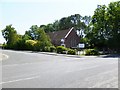
Hillbourne, Catholic Church
St. Anthony of Padua Catholic Church, at the corner of York and Hillbourne Roads.
Image: © Mike Faherty
Taken: 3 Jul 2011
0.11 miles
2
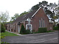
In which I Poole my resources (2)
St Anthony of Padua (RC), Hillbourne
Image: © Basher Eyre
Taken: 22 Apr 2014
0.11 miles
3
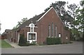
St Anthony of Padua Roman Catholic Church
Although in the district of Hillbourne, the church also serves Broadstone, 1 km to the north.
Image: © mike smith
Taken: 22 Apr 2007
0.12 miles
4
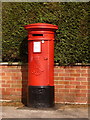
Broadstone: postbox № BH18 39, York Road
The reason for having such a large postbox here is that it was once outside Hillbourne Post Office, a few doors up on the opposite side of the road. It was moved here doubtless after the post office closed (in 2004). It is an Edward VII-reign specimen and its last collection times are 5:15pm on weekdays and 12:15pm on Saturdays.
Image: © Chris Downer
Taken: 2 Apr 2010
0.13 miles
5
Hillbourne Road
On the Waterloo housing estate.
Image: © Mike Faherty
Taken: 3 Jul 2011
0.14 miles
6
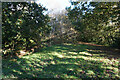
Turf Zone "ThePocketPark"
At Pocket Park off Lower Blandford Road, Broadstone.
Image: © Ian S
Taken: 17 Nov 2022
0.18 miles
7
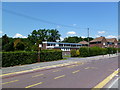
Waterloo Youth Centre
On Kitchener Crescent: http://www.boroughofpoole.com/go.php?structureID=U46406757c6d85&ref=S464AE70804B1A
Image: © Mike Faherty
Taken: 3 Jul 2011
0.18 miles
8
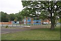
Hillbourne Middle School
This is one of two schools on the same complex.
Image: © mike smith
Taken: 22 Apr 2007
0.18 miles
9
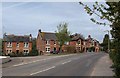
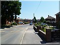
Houses at junction, York Road
These older brick houses make a contrast with the adjacent modern houses shown in Image along Northbrook Road, which is to the left.
Image: © Derek Harper
Taken: 28 Apr 2010
0.19 miles
10
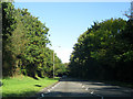
Broadstone Way
Broadstone Way was built on the alignment of the former LSWR line from Broadstone to Bournemouth West. It also carried all the traffic off the southern end of the well-known Somerset & Dorset Joint Railway.
Image: © Peter Kazmierczak
Taken: 28 Oct 2011
0.19 miles