IMAGES TAKEN NEAR TO
Upper Golf Links Road, BROADSTONE, BH18 8BT
Introduction
This page details the photographs taken nearby to Upper Golf Links Road, BH18 8BT by members of the Geograph project.
The Geograph project started in 2005 with the aim of publishing, organising and preserving representative images for every square kilometre of Great Britain, Ireland and the Isle of Man.

There are currently over 7.5m images from over14,400 individuals and you can help contribute to the project by visiting https://www.geograph.org.uk
Image Map (Loading...)


Getting Data...Please wait
Leaflet Map data © OpenStreetMap
Images are licensed for reuse under creativecommons.org/licenses/by-sa/2.0
Notes
- Clicking on the map will re-center to the selected point.
- The higher the marker number, the further away the image location is from the centre of the postcode.
Image Listing (12 Images Found)
Images are licensed for reuse under creativecommons.org/licenses/by-sa/2.0
Image
Details
Distance
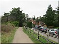
1
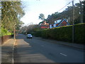
Lower Golf Links Road, Broadstone
This scene is typical of the area. Houses on this road are substantial detached houses.
Image: © Danny P Robinson
Taken: 11 Mar 2006
0.10 miles
2
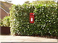
Broadstone: postbox № BH18 21, Lower Golf Links Road
Looking across Lower Golf Links Road from its eastern side, towards this little postbox which is trying to hide in a hedge! It is emptied finally at 5pm on weekdays and at 11:30am on Saturdays.
Image: © Chris Downer
Taken: 2 Apr 2010
0.11 miles
3
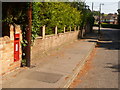
Broadstone: postbox № BH18 42, Lower Golf Links Road
This George VI-reign postbox, set into a frontage wall, is emptied at 5 o’clock on weekday evenings and at 11:30 on Saturday mornings.
Image: © Chris Downer
Taken: 24 May 2009
0.11 miles
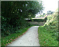
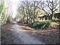
4
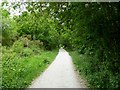
Broadstone, trailway
The Castleman Trailway, following much of the route of the dismantled Southampton to Dorchester Railway. http://www.dorsetforyou.com/castlemantrailway
Image: © Mike Faherty
Taken: 29 May 2011
0.11 miles
5
Castleman Trail, Broadstone
The Castleman Trail leaves the trackbed of the former Southampton & Dorchester Railway here, having to turn sharply right to avoid housing built on the former alignment of the railway.
Image: © Peter Kazmierczak
Taken: 12 Sep 2009
0.14 miles
6
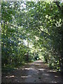
Path on the course of the former railway at Broadstone
A popular route for runners.
Image: © Rod Allday
Taken: 21 Sep 2018
0.15 miles
7
Castleman Trailway, Broadstone
The Castleman trailway heads north out of Broadstone, following the route of the Somerset & Dorset Joint Railway for a short distance. It then turns to the right, crossing a bridge to join the alignment of the former railway to Wimborne. This section of route is also on route 25 of the National Cycle Network.
The path continuing straight ahead remains on the former Somerset & Dorset Joint Railway trackbed, but only for a very short distance.
Both the railway lines closed in the 1960s, as part of the "Beeching Cuts".
Image: © Malc McDonald
Taken: 30 Dec 2024
0.16 miles
8
Castleman Trailway, Broadstone
A view of the Castleman Trailway heading north out of Broadstone. This section of the path is also on route 25 of the National Cycle Network.
This is the site of a railway junction just to the north of Broadstone station. The path curving off to the left is on the trackbed of the former Somerset & Dorset Joint Railway, which closed in 1966. The road and houses to the right occupy the trackbed of the former line to Wimborne which closed in 1964. These closures were part of the "Beeching Cuts".
A short distance further on from where this image was taken, the Castleman Trailway will leave the route of the Somerset & Dorset line and cross over to take up the route towards Wimborne.
Image: © Malc McDonald
Taken: 30 Dec 2024
0.17 miles
9
Castleman Trail, Broadstone
From Upton, near Poole, to Ringwood the route of the Southampton & Dorchester Railway, except for a portion around Wimborne, has been converted into a cyclepath called the Castleman Trail after the Wimborne solicitor largely responsible for the promotion of the railway. The line had opened in 1847 but was closed to passengers in 1964, though goods traffic survived over the pictured section for another 13 years. The path here is running between the garden walls of houses in Lower Golf Links Road, Broadstone, and the golf course and the small brick plinth almost under the nearest tree is all that remains of a footbridge over the railway that allowed players safe access from that road. Today golfers can drive to a new clubhouse from Station Approach, though the station, like the railway and footbridge, is also no more.
Image: © A-M-Jervis
Taken: 10 Dec 2007
0.18 miles
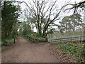
10
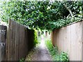
Broadstone, bridleway
Unlikely-looking urban bridleway from Broadstone to Merley, running here between back gardens.
Image: © Mike Faherty
Taken: 29 May 2011
0.19 miles