IMAGES TAKEN NEAR TO
Eldons Drove, POOLE, BH16 6HH
Introduction
This page details the photographs taken nearby to Eldons Drove, BH16 6HH by members of the Geograph project.
The Geograph project started in 2005 with the aim of publishing, organising and preserving representative images for every square kilometre of Great Britain, Ireland and the Isle of Man.

There are currently over 7.5m images from over14,400 individuals and you can help contribute to the project by visiting https://www.geograph.org.uk
Image Map
Images are licensed for reuse under creativecommons.org/licenses/by-sa/2.0
Notes
- Clicking on the map will re-center to the selected point.
- The higher the marker number, the further away the image location is from the centre of the postcode.
Image Listing (25 Images Found)
Images are licensed for reuse under creativecommons.org/licenses/by-sa/2.0
Image
Details
Distance
1
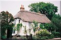
Lytchett Matravers: Prospect House
113 Wareham Road is an attractive thatched cottage in this much modernised village.
Image: © Chris Downer
Taken: Unknown
0.11 miles
2
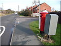
Lytchett Matravers: postbox № BH16 258, Wareham Road
A George VI-reign postbox emptied finally at 4pm on weekdays and 10am on Saturdays.
Image: © Chris Downer
Taken: 17 Jan 2009
0.13 miles
3
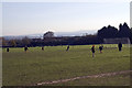
Lytchett Matravers Recreation Ground, Dorset
Sunday morning soccer practice. Poole Harbour is in the distance.
Image: © John Lamper
Taken: 20 Nov 2005
0.13 miles
4
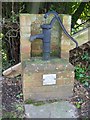
Village pump, Lytchett Matravers
The village pump was restored by the Lytchett Matravers Women's Institute to mark their Diamond Jubilee, November 1980.
Image: © Maigheach-gheal
Taken: 31 Jan 2010
0.13 miles
5
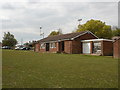
Lytchett Matravers, sports pavilion
On High Street, overlooking the recreation ground; home to Red Triangle Football Club. http://www.clubwebsite.co.uk/lytchettredtriangleyfc/
Image: © Mike Faherty
Taken: 10 May 2010
0.15 miles
6
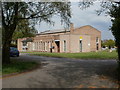
Lytchett Matravers, village hall
On High Street, overlooking the recreation ground; opened 1972.
Image: © Mike Faherty
Taken: 10 May 2010
0.16 miles
7
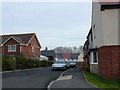
Cecil Place
Cecil Place is a very new residential development on the northern edge of the grid square in the centre of the village. it is so recent that at the time of submission of this photo, the Google satellite image showed only a few piles of concrete blocks on a building site. It did not appear on Streetmap either.
Image: © Nigel Mykura
Taken: 31 Jan 2010
0.17 miles
8
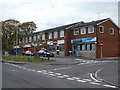
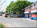
Lytchett Matravers, Purbeck Parade
On High Street, comprising convenience store with post office, hair & beauty salon and estate agents.
Image: © Mike Faherty
Taken: 10 May 2010
0.19 miles
9
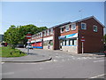
Lytchett Matravers: post office and postbox № BH16 60
The post office is housed within the Tesco Express which takes up two shopfronts. The postbox is a double-aperture one.
Image: © Chris Downer
Taken: 24 May 2009
0.20 miles
10
Lytchett Matravers: shops on High Street
A small parade of shops with their own little service road.
Image: © Chris Downer
Taken: 24 May 2009
0.20 miles