IMAGES TAKEN NEAR TO
Holly Close, POOLE, BH16 5RH
Introduction
This page details the photographs taken nearby to Holly Close, BH16 5RH by members of the Geograph project.
The Geograph project started in 2005 with the aim of publishing, organising and preserving representative images for every square kilometre of Great Britain, Ireland and the Isle of Man.

There are currently over 7.5m images from over14,400 individuals and you can help contribute to the project by visiting https://www.geograph.org.uk
Image Map
Images are licensed for reuse under creativecommons.org/licenses/by-sa/2.0
Notes
- Clicking on the map will re-center to the selected point.
- The higher the marker number, the further away the image location is from the centre of the postcode.
Image Listing (22 Images Found)
Images are licensed for reuse under creativecommons.org/licenses/by-sa/2.0
Image
Details
Distance
1
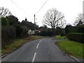
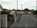
Marsh Lane
Marsh Lane runs south from the Dorchester Rd the B3067 on the western edge of Upton and then curves towards the west. Although it has some old houses such as this thatched one, it has several large new detached houses.
Image: © Nigel Mykura
Taken: 31 Jan 2010
0.08 miles
2
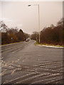
Upton: sleet on Policeman?s Lane junction
Not ten minutes ago it was a sunny day a couple of miles south. Now, sleet covers the roads in what appeared to be a very localised flurry of sleet – only a mile or two east it was definitely rain and the roads were not hazardous at all.
Image: © Chris Downer
Taken: 20 Feb 2010
0.11 miles
3
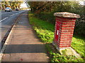
Upton: postbox № BH16 2, Dorchester Road
This George V-reign postbox, set into its own brick pillar, is emptied finally at 5:30pm on weekdays and at 11am on Saturdays.
Image: © Chris Downer
Taken: 15 Nov 2009
0.12 miles
4
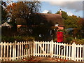
Upton: Christmas Cottage
This attractive thatched cottage stands on the now short, dead-end bit of Dorchester Road – when the by-pass was put through the main carriageway was diverted to go over the bridge. It has a recycled Royal Mail postbox for its incoming mail.
Image: © Chris Downer
Taken: 15 Nov 2009
0.13 miles
5
Lytchett Minster: footprints in the sleet
Not ten minutes ago it was a sunny day a couple of miles south. Now, sleet covers the roads in what appeared to be a very localised flurry of sleet – only a mile or two east it was definitely rain and the roads were not hazardous at all.
Where cars came along here with the wheels running slightly off the course of previous ones, the spray coming from them was quite impressive and it was a good idea to give them as wide a berth as possible!
Image: © Chris Downer
Taken: 20 Feb 2010
0.14 miles
6
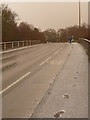
A35 Westbound, Dorchester Road Bridge
The Bridge carrying Dorchester Road (B3067) over the westbound A35 near Lytchett Minster.
Image: © David Dixon
Taken: 18 Dec 2012
0.14 miles
7
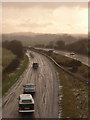
Lytchett Minster: the A35 in sleet
Not ten minutes ago it was a sunny day a couple of miles south. Now, sleet covers the roads in what appeared to be a very localised flurry of sleet – only a mile or two east it was definitely rain and the roads were not hazardous at all.
The reason for the surprising route of these tyre-marks, all changing lanes at the same point, is an incident that has just occurred out-of-shot to the left – see Image
Image: © Chris Downer
Taken: 20 Feb 2010
0.14 miles
8
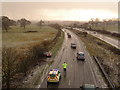
Lytchett Minster: spin-off on the A35
Not ten minutes ago it was a sunny day a couple of miles south. Now, sleet covers the roads in what appeared to be a very localised flurry of sleet – only a mile or two east it was definitely rain and the roads were not hazardous at all.
The sudden icy conditions seem to have caused a few incidents, as a number of ambulances and police cars were going around with blue lights flashing and sirens on. Here, someone has slid off the road and the police have just this second arrived.
Image: © Chris Downer
Taken: 20 Feb 2010
0.14 miles
9
Upton, bungalows
Modern bungalows in Beacon Park Road.
Image: © Mike Faherty
Taken: 1 Oct 2009
0.15 miles
10
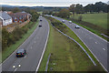
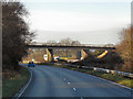
Purbeck : Upton Bypass A35
Looking along the Upton Bypass from the B3067 bridge over it.
Image: © Lewis Clarke
Taken: 28 Oct 2017
0.16 miles