IMAGES TAKEN NEAR TO
Lincoln Avenue, BOURNEMOUTH, BH1 4QS
Introduction
This page details the photographs taken nearby to Lincoln Avenue, BH1 4QS by members of the Geograph project.
The Geograph project started in 2005 with the aim of publishing, organising and preserving representative images for every square kilometre of Great Britain, Ireland and the Isle of Man.

There are currently over 7.5m images from over14,400 individuals and you can help contribute to the project by visiting https://www.geograph.org.uk
Image Map
Images are licensed for reuse under creativecommons.org/licenses/by-sa/2.0
Notes
- Clicking on the map will re-center to the selected point.
- The higher the marker number, the further away the image location is from the centre of the postcode.
Image Listing (152 Images Found)
Images are licensed for reuse under creativecommons.org/licenses/by-sa/2.0
Image
Details
Distance
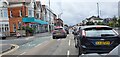
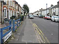
1
Springbourne, Bournemouth.
This quiet residential area is at the junction of Spring Rd and Lincoln Ave. Four small roads grouped together are named after early American presidents. The others are Garfield, Washington, and Cleveland and all four run into Spring Rd. A bit further away there are also Jefferson, Madison and Harrison.
Image: © Nigel Mykura
Taken: 4 Nov 2008
0.04 miles
2
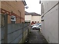
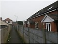
Springbourne: footpath J01 approaches Spring Road
Looking along a public footpath running from Spring Road (ahead) to Windham Road, the next parallel street.
See Image for the view towards us from over the road ahead, and Image for the next view on the path behind us.
Image: © Chris Downer
Taken: 14 Feb 2017
0.05 miles
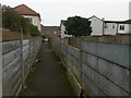
3
Springbourne: footpath J01 from Spring Road
Looking along a public footpath from Spring Road towards Windham Road, the next parallel street.
Many of the footpaths in Bournemouth have been given names in the last couple of years, a safety initiative whose intention is that, in the event of calling for help, one's location can be more easily described. This one has been named Spring Walk (see sign on left), no doubt because of its connection with Spring Road and the suburb of Springbourne.
See Image for the next in a series of photos along the path.
Image: © Chris Downer
Taken: 14 Feb 2017
0.05 miles
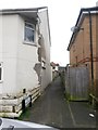
4
Springbourne: footpath J01 passes 150a-c Spring Road
Looking along a public footpath running from Spring Road to Windham Road (ahead), the next parallel street. Meanwhile, alongside it is a small terrace of houses built as infill in what was originally back garden of 150 Spring Road, the house just behind us.
See Image for the next view on the path ahead, and Image for the next view behind.
Image: © Chris Downer
Taken: 14 Feb 2017
0.06 miles
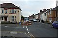
6

Former St Mary Springbourne
Erected in 1926. Now used as the Bourne Spring Centre.
Image: © Michael FORD
Taken: Unknown
0.08 miles
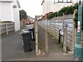
7
Springbourne: damaged fence on footpath J01
Looking along a public footpath running from Spring Road to Windham Road (ahead), the next parallel street. Meanwhile, alongside it runs a driveway to flats built as infill in what was originally back gardens - the concrete fence separating the path from the drive is damaged but the panel is still here.
See Image for the view along the path from Windham Road ahead, and Image for the next photo on the path behind.
Image: © Chris Downer
Taken: 14 Feb 2017
0.08 miles
8
Springbourne: footpath J01 and a driveway run parallel
Looking along a public footpath from Windham Road towards Spring Road, the next parallel street. Meanwhile, alongside it runs a driveway to houses built as infill in what was originally the back garden of a Spring Road house.
Many of the footpaths in Bournemouth have been given names in the last couple of years, a safety initiative whose intention is that, in the event of calling for help, one's location can be more easily described. This one has been named Spring Walk, no doubt because of its connection with Spring Road and the suburb of Springbourne.
See Image for the next in a series of photos along the path.
Image: © Chris Downer
Taken: 14 Feb 2017
0.09 miles
9
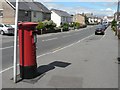
Springbourne: postbox № BH1 15, Cleveland Road
This box was previously at the corner of Windham and Cleveland Roads – the next corner south – until September 2002 when it was removed while road works took place. After a couple if years' absence it was reinstated here on the corner of Spring Road.
With thanks to Wilf Vernon for the additional information.
Image: © Chris Downer
Taken: 19 Jul 2008
0.10 miles