IMAGES TAKEN NEAR TO
Walpole Road, BOURNEMOUTH, BH1 4EZ
Introduction
This page details the photographs taken nearby to Walpole Road, BH1 4EZ by members of the Geograph project.
The Geograph project started in 2005 with the aim of publishing, organising and preserving representative images for every square kilometre of Great Britain, Ireland and the Isle of Man.

There are currently over 7.5m images from over14,400 individuals and you can help contribute to the project by visiting https://www.geograph.org.uk
Image Map
Images are licensed for reuse under creativecommons.org/licenses/by-sa/2.0
Notes
- Clicking on the map will re-center to the selected point.
- The higher the marker number, the further away the image location is from the centre of the postcode.
Image Listing (196 Images Found)
Images are licensed for reuse under creativecommons.org/licenses/by-sa/2.0
Image
Details
Distance
1
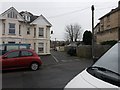
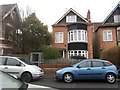
Boscombe: Walpole Lane from Walpole Road
Walpole Lane is essentially a rear driveway for the premises on the eastern side of The Crescent (to our right) and a few garages. It also forms public footpath F04 to Salisbury Road.
See Image for the sign on the lamppost just behind us, and Image for the next in a series of photos along the lane.
Image: © Chris Downer
Taken: 14 Feb 2017
0.03 miles
2
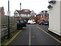
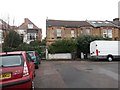
Boscombe: Walpole Lane arrives on Walpole Road
Walpole Lane is essentially a rear driveway for the premises on the eastern side of The Crescent (to our left) and a few garages. It also forms public footpath F04 between Walpole and Salisbury Roads.
See Image for the view towards us from across the road, and Image for the next in a series of photos along the lane behind us.
Image: © Chris Downer
Taken: 14 Feb 2017
0.03 miles
3
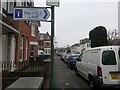
Boscombe: the sign for Walpole Lane
Walpole Lane is a rear driveway coming off Walpole Road just to our right, and is also a public footpath to Salisbury Road. See Image for the view along the lane.
Image: © Chris Downer
Taken: 14 Feb 2017
0.04 miles
4

Boscombe: westward on Walpole Lane
Walpole Lane is essentially a rear driveway for the premises on the eastern side of The Crescent (to our left) and a few other garages. It also forms public footpath F04 between Walpole (ahead) and Salisbury Roads.
See Image for the next view on the path ahead, and Image for the next view behind us.
Image: © Chris Downer
Taken: 14 Feb 2017
0.04 miles
5
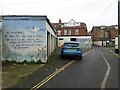
Boscombe: philosophical artwork on a Walpole Lane garage
Walpole Lane is essentially a rear driveway for the premises on the eastern side of The Crescent (to our right) and these garages. It also forms public footpath F04 between Walpole (behind us) and Salisbury Roads.
See Image for the next view on the path ahead, and Image for the next view behind us.
Image: © Chris Downer
Taken: 14 Feb 2017
0.05 miles
6
Boscombe: footpath F03 used to start at that metal gate
Looking across Grosvenor Gardens, ahead of us we see a sturdy gate which blocks what was once a short public footpath to Salisbury Road. The footpath is marked on the 1980s definitive rights of way map, but has since been extinguished and is no longer a public right of way.
See Image for the view through the gate, with links to photos taken from the opposite end of the path.
Image: © Chris Downer
Taken: 14 Feb 2017
0.05 miles
7
Boscombe: gate at the start of former footpath F03
Looking along the end of Salisbury Road, ahead of us we see a sturdy gate which blocks what was once a short public footpath to Grosvenor Gardens. The footpath is marked on the 1980s definitive rights of way map, but has since been extinguished and is no longer a public right of way.
See Image for the view through the gate, with links to photos taken from the opposite end of the path.
Image: © Chris Downer
Taken: 14 Feb 2017
0.05 miles
8
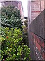
Boscombe: former footpath F03 from Salisbury Road
Looking through the sturdy gate which blocks what was once a short public footpath to Grosvenor Gardens. The footpath is marked on the 1980s definitive rights of way map, but has since been extinguished and is no longer a public right of way.
See Image for a view of the gate from behind us, and Image for the view towards us from the similar gate at the other end - in which the pile of blocks visible in the background are better viewed.
Image: © Chris Downer
Taken: 14 Feb 2017
0.05 miles
9
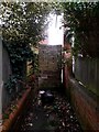
Boscombe: a pile of blocks blocks former footpath F03
Looking through the sturdy gate which blocks what was once a short public footpath to Salisbury Road from here on Grosvenor Gardens. The footpath is marked on the 1980s definitive rights of way map, but has since been extinguished and is no longer a public right of way.
If the gate was somehow breached, this pile of concrete blocks would surely thwart any further access.
See Image for a view of the gate from behind us, and Image for the view towards us from the similar gate at the other end.
Image: © Chris Downer
Taken: 14 Feb 2017
0.05 miles
10
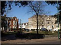
The Crescent, Boscombe
Another view of Image, also across Christchurch Road, with buildings either side of the junction with Walpole Road.
Image: © Derek Harper
Taken: 10 Mar 2010
0.05 miles