IMAGES TAKEN NEAR TO
Bath Road, BOURNEMOUTH, BH1 2PP
Introduction
This page details the photographs taken nearby to Bath Road, BH1 2PP by members of the Geograph project.
The Geograph project started in 2005 with the aim of publishing, organising and preserving representative images for every square kilometre of Great Britain, Ireland and the Isle of Man.

There are currently over 7.5m images from over14,400 individuals and you can help contribute to the project by visiting https://www.geograph.org.uk
Image Map
Images are licensed for reuse under creativecommons.org/licenses/by-sa/2.0
Notes
- Clicking on the map will re-center to the selected point.
- The higher the marker number, the further away the image location is from the centre of the postcode.
Image Listing (487 Images Found)
Images are licensed for reuse under creativecommons.org/licenses/by-sa/2.0
Image
Details
Distance
1
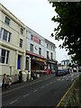
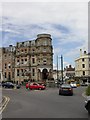
Bournemouth: Jacey House
The 13 bus to Wimborne passes Jacey House at Image Now occupied by a restaurant on the ground floor, this was originally offices. In the red panel in the centre of the circular section is the date 1891. Until a few years ago the very top was adorned with the words 'JACEY HOUSE' in large letters, as can be seen in the background of Image
Image: © Chris Downer
Taken: 18 Mar 2008
0.01 miles
2
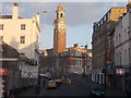
Bournemouth: approaching the Lansdowne by bus
The view from the top deck of a bus along the final, uphill stretch of Old Christchurch Road as it reaches Image Directly ahead is the fine College clock tower which is discussed in more detail here: Image and Image
Image: © Chris Downer
Taken: 25 Mar 2015
0.01 miles
3
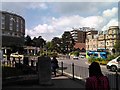
Old Christchurch Road - viewed from Roundabout
Image: © Betty Longbottom
Taken: 21 Apr 2016
0.01 miles
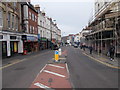
4
Bath Road - viewed from Roundabout
Image: © Betty Longbottom
Taken: 21 Apr 2016
0.01 miles
5
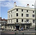
Bournemouth, Ask
Italian restaurant at the corner of Old Christchurch and Bath Roads. Compare its graceful Victorian proportions with the 1960s brutalism of Image opposite.
Image: © Mike Faherty
Taken: 12 Jul 2010
0.01 miles
6
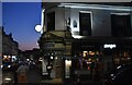
Bournemouth, O'Neill's
Pub/bar at the corner of Old Christchurch & Lansdowne Roads. Internally, two bars on different levels, each with drinking/eating areas (the upper is less noisy). Irish themed; no cask ales on offer. For some customer comments, see http://www.beerintheevening.com/pubs/s/19/199/ONeills/Bournemouth
Image: © Mike Faherty
Taken: 12 Jul 2010
0.02 miles
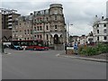
8
Bournemouth Lansdowne from Bath Road ca 1975
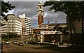
The large building on the left is Royal London House, then the offices of Royal London Insurance. Today it is occupied as Bournemouth University student accommodation, with on the ground floor a KFC restaurant. The building on this site 70 years ago was the Metropole Hotel that suffered so terribly in the devastating Luftwaffe air raid of 23 May 1943 http://www.dorsetlife.co.uk/2013/04/a-minute-of-intense-devastation-bournemouths-bloodiest-air-raid/. On the right is the Roundhouse Hotel opened in 1969, and beyond, the *Lansdowne clock tower of the Bournemouth Municipal College that opened in 1913. Bournemouth Public Library formed a part of this building until a new purpose-built library was opened in the Triangle in 2002.
*A gruesome discovery was made at the clock tower after the 1943 air raid, when a body that had been blown clear of the Metropole Hotel, was only recovered after laying undiscovered for over a week. Authorities had been alerted to investigate after it was observed that seagulls were mysteriously gathering there. A memorial to the dead was unveiled nearby on the occasion of the 70th anniversary of the raid on 23 May 2013. Image
Image: © Ronald Searle
Taken: Unknown
0.02 miles
9
Christchurch Road Roundabout, with Roundhouse in shot
This shot was taken further round on the roundabout, with the Roundhouse in view on the left. View taken looking west-southwest.
Image: © Robert Lamb
Taken: 14 Jun 2010
0.02 miles