IMAGES TAKEN NEAR TO
Rodney Close, POOLE, BH12 5BQ
Introduction
This page details the photographs taken nearby to Rodney Close, BH12 5BQ by members of the Geograph project.
The Geograph project started in 2005 with the aim of publishing, organising and preserving representative images for every square kilometre of Great Britain, Ireland and the Isle of Man.

There are currently over 7.5m images from over14,400 individuals and you can help contribute to the project by visiting https://www.geograph.org.uk
Image Map
Images are licensed for reuse under creativecommons.org/licenses/by-sa/2.0
Notes
- Clicking on the map will re-center to the selected point.
- The higher the marker number, the further away the image location is from the centre of the postcode.
Image Listing (36 Images Found)
Images are licensed for reuse under creativecommons.org/licenses/by-sa/2.0
Image
Details
Distance
1
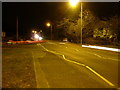
Poole : Alder Road A3040
This road leads to Wallisdown Roundabout, on the junction nearest the photographer is South Park Road.
Image: © Lewis Clarke
Taken: 8 Mar 2010
0.07 miles
3
South Park Road
The Bourne Stream runs through the trees and bushes on the left.
Image: © David Lally
Taken: 30 Jun 2010
0.10 miles
5
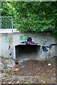
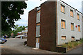
Ex Fire Service Headquarters
Now boarded-up and presumably awaiting demolition. Off Alder Road in the Bourne Valley.
Image: © David Lally
Taken: 30 Jun 2010
0.12 miles
6
Ex Fire Service Headquarters
Now boarded-up and presumably awaiting demolition. Off Alder Road in the Bourne Valley.
Image: © David Lally
Taken: 30 Jun 2010
0.13 miles
7
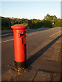
Branksome: postbox № BH12 255, Bloxworth Road
This Elizabeth II-reign postbox is casting a very long shadow as the evening sun shines squarely down Bloxworth Road. It is currently without a collection-times plate.
Image: © Chris Downer
Taken: 27 Jun 2009
0.13 miles
8
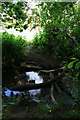
Improvised crossing-point
Various branches and bits of masonry arranged allowing one to cross the Bourne Stream.
Image: © David Lally
Taken: 30 Jun 2010
0.13 miles
9
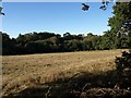
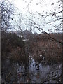
Bourne valley
A field surrounded by woodland in the valley, which forms a green strip running through the Poole and Bournemouth suburbs.
Image: © Derek Harper
Taken: 12 Oct 2009
0.14 miles
10
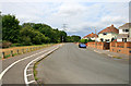
Poole : Alder Road Roundabout
A roundabout with Bloxworth Road to the right and Sainsbury's ahead.
Image: © Lewis Clarke
Taken: 8 Mar 2010
0.15 miles