IMAGES TAKEN NEAR TO
Surrey Road, POOLE, BH12 1HG
Introduction
This page details the photographs taken nearby to Surrey Road, BH12 1HG by members of the Geograph project.
The Geograph project started in 2005 with the aim of publishing, organising and preserving representative images for every square kilometre of Great Britain, Ireland and the Isle of Man.

There are currently over 7.5m images from over14,400 individuals and you can help contribute to the project by visiting https://www.geograph.org.uk
Image Map
Images are licensed for reuse under creativecommons.org/licenses/by-sa/2.0
Notes
- Clicking on the map will re-center to the selected point.
- The higher the marker number, the further away the image location is from the centre of the postcode.
Image Listing (97 Images Found)
Images are licensed for reuse under creativecommons.org/licenses/by-sa/2.0
Image
Details
Distance
1
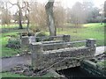
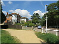
Coy Pond Gardens: cycle/footbridge
This bridge marks the point where the 'greenway', a cycleway that tends to occupy the path along the southern edge of the Gardens from Bournemouth Square, crosses the stream and takes cyclists to northern suburbs of Poole via motorable roads.
Image: © Chris Downer
Taken: 12 Jan 2008
0.04 miles
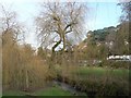
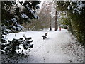
2
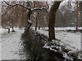
Branksome: snow in Coy Pond Gardens
The Bournemouth conurbation's first significant snowfall for three years creates an almost monochrome scene here in Coy Pond Gardens. We look along the Bourne Stream, which flows down the centre of these gardens, which become Bournemouth's Upper, Central and then Lower Gardens to reach the pier, 2½ miles ahead.
Image: © Chris Downer
Taken: 1 Mar 2018
0.04 miles
3
Coy Pond Gardens: some wonky trees
Some of these trees have peculiar shaped trunks; the one on the left is arguably straighter yet less upright. This section of the Gardens is actually in the borough of Poole.
Image: © Chris Downer
Taken: 12 Jan 2008
0.04 miles
4
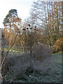
Coy Pond Gardens, cardoon heads
Statuesque dried & frosty seedheads of cardoon (Cynara cardunculus) by the Bourne Stream in Poole's Upper Gardens. For more information on the gardens, see http://boroughofpoole.com/facilities/ref:F465e9bc752c16/
Image: © Mike Faherty
Taken: 9 Jan 2009
0.05 miles
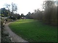
5
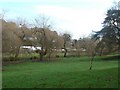
Coy Pond Gardens and Coy Pond Road, near Bournemouth
A path in Coy Pond Gardens, with a view onto Coy Pond Road. Although this location is close to Bournemouth, it lies within the neighbouring Borough of Poole.
Image: © Malc McDonald
Taken: 25 Aug 2021
0.05 miles
6
Coy Pond Gardens: looking across to Coy Pond Road
The rockery section of the Gardens (see Image) can be seen through the trees, on the other side of the Gardens. Coy Pond Road is immediately beyond.
Image: © Chris Downer
Taken: 12 Jan 2008
0.05 miles
7
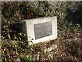
Coy Pond Gardens: rockery plaque
A plaque laid on the rockery edge of the Gardens, backing onto Coy Pond Road.
It states: This stone was laid on 24th May 2003 by the High Sheriff of Dorset, Mrs F.S. Weld, to commemorate the 50th year of the building of this rockery and the co-operation between the Borough of Poole and the Friends of Coy Pond through its restoration. Also present were the mayor of Poole, Cllr. Ray Smith, officers of the Council and councillors from Poole and Bournemouth.
Image: © Chris Downer
Taken: 12 Jan 2008
0.05 miles
8
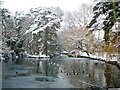
Coy Pond in the snow
I was stood on the public path of Coy Pond Road looking North. You can see that the left hand side of the pond was frozen.
Image: © Mike Marriott
Taken: 3 Dec 2010
0.06 miles
9
Coy Pond Gardens in the snow
I am stood on the gravel path that parallels the stream that runs through the middle of Coy Pond Gardens.
Image: © Mike Marriott
Taken: 3 Dec 2010
0.06 miles
10
Coy Pond Gardens: alongside Coy Pond Road
This part of the gardens, near the top end and in the borough of Poole, is alongside Coy Pond Road which can be seen on the left.
Image: © Chris Downer
Taken: 12 Jan 2008
0.06 miles