IMAGES TAKEN NEAR TO
Dean Park Road, BOURNEMOUTH, BH1 1JB
Introduction
This page details the photographs taken nearby to Dean Park Road, BH1 1JB by members of the Geograph project.
The Geograph project started in 2005 with the aim of publishing, organising and preserving representative images for every square kilometre of Great Britain, Ireland and the Isle of Man.

There are currently over 7.5m images from over14,400 individuals and you can help contribute to the project by visiting https://www.geograph.org.uk
Image Map
Images are licensed for reuse under creativecommons.org/licenses/by-sa/2.0
Notes
- Clicking on the map will re-center to the selected point.
- The higher the marker number, the further away the image location is from the centre of the postcode.
Image Listing (57 Images Found)
Images are licensed for reuse under creativecommons.org/licenses/by-sa/2.0
Image
Details
Distance
1

Bournemouth: postbox № BH2 22, Wimborne Road
Looking along this very first section of Wimborne Road: the house numbers here are in the 20s, while they eventually reach 1823 (odd) and 1714 (even).
Image: © Chris Downer
Taken: 10 Jul 2008
0.05 miles
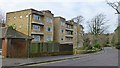
2
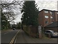
St Valerie Road
Looking toward the junction with Wimborne Road.
The apartment block on the right is 20 Wimborne Road.
The photographer was stood next to the lamp post in this picture Image
Image: © David Lally
Taken: 14 Jan 2017
0.08 miles
3
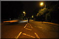
Bournemouth : Wimborne Road A347
A man is walking down the centre of Wimborne Road. He may get run over.
Image: © Lewis Clarke
Taken: 4 Oct 2010
0.08 miles
4
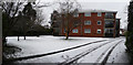
Bournemouth : Flats on Wimborne Road
Snow in the gardens of flats on Wimborne Road.
Image: © Lewis Clarke
Taken: 6 Feb 2009
0.09 miles
5
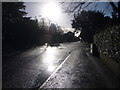
Bournemouth: first stretch of Wimborne Road
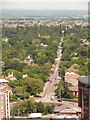
Wimborne Road is easily Bournemouth's longest road, running for over four miles in the direction of Wimborne Minster, culminating in the town's highest house numbers - 1716 even and 1823 odd - at Bear Cross in Image (see Image). (However, a couple of hundred numbers are missed out on both sides at the southern end of Winton.)
Here, we look along the stretch from its start at the top of Richmond Hill in the town centre. The bright sun is reflecting off surface water in the gutter after a night and morning of heavy rain.
Braidley Road is off to the right.
Image: © Chris Downer
Taken: 30 Dec 2013
0.09 miles
6
Bournemouth: Wimborne Road heads out of town
The very beginning of Wimborne Road, with house numbers in single digits which will eventually reach 1823 on the odds side a few miles further on. This first stretch of Wimborne Road is a continuation north at the top of Richmond Hill, heading from The Square in the heart of town – Richmond Hill Roundabout can be seen at the bottom of the picture (see Image).
At the end of this long straight is Cemetery Junction (see Image) with the cemetery directly ahead, identified by the chapel of rest which is now Image
The other spire, to the left, belongs to the Image
Image: © Chris Downer
Taken: 21 Jun 2010
0.10 miles
7
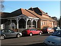
Bournemouth: Cooper Dean Pavilion
Named after two former local landowner sisters, the Miss Cooper-Deans, the Cooper Dean Pavilion belongs to Image, the former shared home of Hampshire County Cricket Club.
Image: © Chris Downer
Taken: 11 Dec 2007
0.11 miles
8
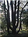
An interestingly shaped tree
Situated in Image, this tree brings to mind one of those church candle-holders.
Image: © Chris Downer
Taken: 11 Dec 2007
0.11 miles
9
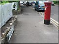
Bournemouth: postbox № BH1 48, Cavendish Road
A Victorian postbox on Cavendish Road, which completely encircles Image
Image: © Chris Downer
Taken: 26 Jun 2008
0.12 miles
10
Apartments on St Valerie Road
A touch of art deco in the curved balconies.
Image: © David Lally
Taken: 25 Jan 2015
0.12 miles