IMAGES TAKEN NEAR TO
Dean Park Road, BOURNEMOUTH, BH1 1HU
Introduction
This page details the photographs taken nearby to Dean Park Road, BH1 1HU by members of the Geograph project.
The Geograph project started in 2005 with the aim of publishing, organising and preserving representative images for every square kilometre of Great Britain, Ireland and the Isle of Man.

There are currently over 7.5m images from over14,400 individuals and you can help contribute to the project by visiting https://www.geograph.org.uk
Image Map
Images are licensed for reuse under creativecommons.org/licenses/by-sa/2.0
Notes
- Clicking on the map will re-center to the selected point.
- The higher the marker number, the further away the image location is from the centre of the postcode.
Image Listing (329 Images Found)
Images are licensed for reuse under creativecommons.org/licenses/by-sa/2.0
Image
Details
Distance
1
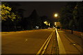
Bournemouth : Wimborne Road A347
Wimbore Road between the Wessex Way and Charminster Road.
Image: © Lewis Clarke
Taken: 4 Oct 2010
0.04 miles
2
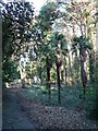
Bournemouth: palms in Horseshoe Common
This is the path that runs around the perimeter of Image, at the back of properties on Dean Park Road, giving it its distinctive shape and, therefore, name.
Image: © Chris Downer
Taken: 11 Dec 2007
0.04 miles
3
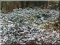
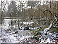
Bournemouth: snow-covered foliage
A wintry scene in Image I am sure the snow would have been thicker first thing this morning.
Image: © Chris Downer
Taken: 2 Feb 2009
0.06 miles
4
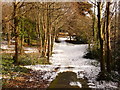
Bournemouth: heading into Horseshoe Common after snow
Heading east from Richmond Hill Roundabout, into Image as much of yesterday's snow refuses to shift.
Image: © Chris Downer
Taken: 8 Jan 2010
0.06 miles
5
Bournemouth: reconfigured slip road on the Wessex Way
This slip road has been the location of many a minor shunt, as it joins the main Wessex Way with only a very short acceleration lane, and with restricted vision on a blind left-hand sweep of the main carriageway. (See Image for a view of the blind spot and the previous markings.)
The junction has therefore sensibly been re-marked, with the slip road becoming the left-hand lane, and only the right-hand lane arriving here on the main line of the road.
This is signified by the road sign and also appreciable by way of the road markings in the background.
Meanwhile, the footpath on the left drops down to Horseshoe Common.
Image: © Chris Downer
Taken: 6 Mar 2017
0.06 miles
6
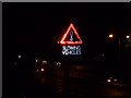
Bournemouth: newish LED slip-road warning
Looking down the eastbound on-slip to the A338 town-centre by-pass. This particular slip road descends quite steeply, is relatively short, and joins the main carriageway at a gentle left curve, limiting visibility of both routes from each other. This warning sign therefore warns that traffic ahead may slow suddenly.
Image: © Chris Downer
Taken: 10 Jan 2014
0.07 miles
7
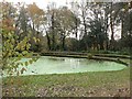
Bournemouth: Horseshoe Common pond
A small pond (which doubles as a litter bin) in Image
Image: © Chris Downer
Taken: 22 Nov 2007
0.08 miles
8
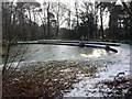
Bournemouth: frozen-over pond in Horseshoe Common
Overnight snow and freezing temperatures have left their mark on and around Image this lunchtime.
Image: © Chris Downer
Taken: 2 Feb 2009
0.08 miles
9
Bournemouth: trees in Horseshoe Common pond
The northern side of Image is more natural, unlike the southern side which has been banked with concrete as seen in the background.
Image: © Chris Downer
Taken: 2 Feb 2009
0.08 miles
10
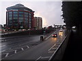
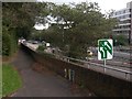
Bournemouth: town-centre by-pass slip roads
Looking across the Richmond Hill interchange as westbound motorists prepare to join the main carriageway. The prominent office block in the background is Image
Image: © Chris Downer
Taken: 14 Feb 2014
0.08 miles