IMAGES TAKEN NEAR TO
Granville Place, BOURNEMOUTH, BH1 1DP
Introduction
This page details the photographs taken nearby to Granville Place, BH1 1DP by members of the Geograph project.
The Geograph project started in 2005 with the aim of publishing, organising and preserving representative images for every square kilometre of Great Britain, Ireland and the Isle of Man.

There are currently over 7.5m images from over14,400 individuals and you can help contribute to the project by visiting https://www.geograph.org.uk
Image Map
Images are licensed for reuse under creativecommons.org/licenses/by-sa/2.0
Notes
- Clicking on the map will re-center to the selected point.
- The higher the marker number, the further away the image location is from the centre of the postcode.
Image Listing (1625 Images Found)
Images are licensed for reuse under creativecommons.org/licenses/by-sa/2.0
Image
Details
Distance
1
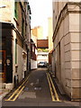
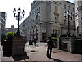
Bournemouth: Granville Place
This alley essentially acts as a service road to the rear of the shops in Old Christchurch Road, which runs parallel to the right. It does have some residential postal addresses, probably recent conversions of business premises.
Image: © Chris Downer
Taken: 5 Oct 2010
0.00 miles
2
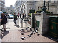
Bournemouth : Old Christchurch Road - Pigeons
Image: © Lewis Clarke
Taken: 22 Apr 2009
0.01 miles
4
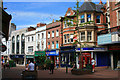
Old Christchurch Road
A great mix of buildings remain on this shopping street. The Dalkeith building out-of-shot on the right http://www.geograph.org.uk/photo/1943845 is listed but as far as I can determine nothing visible here is.
Image: © David Lally
Taken: 6 Jun 2010
0.02 miles
5
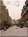
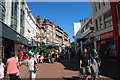
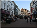
Bournemouth: Old Christchurch Road
Looking down the upper pedestrianised section of this shopping street, towards the town centre. The Christmas lights, which were switched off the night before last, have been replaced by a little festive weather, pretty unusual for Bournemouth.
Image: © Chris Downer
Taken: 6 Jan 2010
0.02 miles
6
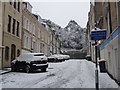
Bournemouth: snow in Verulam Place
The attractive terrace of town houses in Image hardly detracts from the monochrome tendencies here, after Bournemouth's heaviest snow for 17 years fell overnight.
Image: © Chris Downer
Taken: 2 Dec 2010
0.02 miles
8
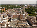
Bournemouth: Old Christchurch Road and St. Peter?s church
It is only from up in Image that the central parish church and the pedestrianised Old Christchurch Road could both be viewed in one picture. The steeple of the church is almost pointing at the various office blocks of the Lansdowne – the chief business area of the town.
Image: © Chris Downer
Taken: 21 Jun 2010
0.02 miles
10
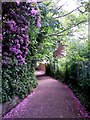
Bournemouth: rhododendrons over Dalkeith Lane
Looking down this public right of way (footpath C04) as it descends from Richmond Gardens to Old Christchurch Road.
See Image] for the next view on the path ahead, and Image for the next view behind us - each with links to further photos along the route.
Image: © Chris Downer
Taken: 15 Jun 2016
0.02 miles