IMAGES TAKEN NEAR TO
Tonge Road, BOURNEMOUTH, BH11 9DH
Introduction
This page details the photographs taken nearby to Tonge Road, BH11 9DH by members of the Geograph project.
The Geograph project started in 2005 with the aim of publishing, organising and preserving representative images for every square kilometre of Great Britain, Ireland and the Isle of Man.

There are currently over 7.5m images from over14,400 individuals and you can help contribute to the project by visiting https://www.geograph.org.uk
Image Map (Loading...)


Getting Data...Please wait
Leaflet Map data © OpenStreetMap
Images are licensed for reuse under creativecommons.org/licenses/by-sa/2.0
Notes
- Clicking on the map will re-center to the selected point.
- The higher the marker number, the further away the image location is from the centre of the postcode.
Image Listing (120 Images Found)
Images are licensed for reuse under creativecommons.org/licenses/by-sa/2.0
Image
Details
Distance
1
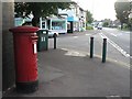
Kinson: postbox № BH11 373, Wimborne Road
This postbox stands outside Image
Image: © Chris Downer
Taken: 21 Jul 2008
0.06 miles
3
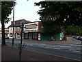
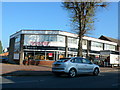
Kinson: post office
The post office is at the western end of the main shopping area of Kinson, at 1518 Wimborne Road.
Image: © Chris Downer
Taken: 21 Jul 2008
0.06 miles
4
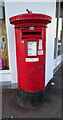
Elizabeth II postbox on Wimborne Road
Postbox No. BH11 373.
Image: © JThomas
Taken: 24 Mar 2022
0.06 miles
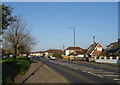
5
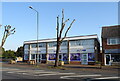
Furniture Store
This shop is on the north side of the Wimborne Rd the A341 at Kinson. It is on the junction with Truman Rd.
Image: © Nigel Mykura
Taken: 15 Nov 2011
0.06 miles
7
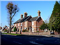
House on Wimborne Rd
This red brick Victorian detached house with a small modern extension sits at the junction with Truman Rd. The road in the foreground is the A341 Wimborne Rd.
Image: © Nigel Mykura
Taken: 15 Nov 2011
0.07 miles
8
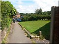
Kinson: footpath E12 reaches Vince Close
This public footpath, ultimately from Summers Avenue, arrives at its destination, the dead end of Vince Close. The house on the right has a high back-garden fence, but no fence to the front garden.
See Image for the view up the path from ahead, and Image] for the next view on the path from the open space behind us.
Image: © Chris Downer
Taken: 10 Jul 2016
0.07 miles
9
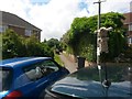
Kinson: footpath E12 from Vince Close
The dead end of Vince Close is busy with parked cars as we look across the roof of one of them, along this public footpath which leads onto public open space and continues to Summers Avenue.
The car here has a soft toy affixed to the aerial, which must help to locate the car in busy car parks.
See Image for the next view along the path, and links to further photos all along the route.
Image: © Chris Downer
Taken: 10 Jul 2016
0.07 miles
10
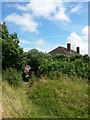
Kinson: footpath E12 heads for Vince Close
This public footpath has arrived on open space from Summers Avenue, and now heads back into suburbia by way of the little path ahead of us. It comes out at the dead end of Vince Close.
See Image for the next view along the path ahead, and Image for the view across the open space behind us.
Image: © Chris Downer
Taken: 10 Jul 2016
0.08 miles