IMAGES TAKEN NEAR TO
Truman Road, BOURNEMOUTH, BH11 9BW
Introduction
This page details the photographs taken nearby to Truman Road, BH11 9BW by members of the Geograph project.
The Geograph project started in 2005 with the aim of publishing, organising and preserving representative images for every square kilometre of Great Britain, Ireland and the Isle of Man.

There are currently over 7.5m images from over14,400 individuals and you can help contribute to the project by visiting https://www.geograph.org.uk
Image Map (Loading...)


Getting Data...Please wait
Leaflet Map data © OpenStreetMap
Images are licensed for reuse under creativecommons.org/licenses/by-sa/2.0
Notes
- Clicking on the map will re-center to the selected point.
- The higher the marker number, the further away the image location is from the centre of the postcode.
Image Listing (129 Images Found)
Images are licensed for reuse under creativecommons.org/licenses/by-sa/2.0
Image
Details
Distance
1
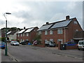
Bournemouth: council houses in Roosevelt Crescent
Bournemouth Borough Council has recently started a programme of installing photovoltaic cells on the roofs of its housing stock. I presume those houses without them are probably no longer in council ownership.
Image: © Chris Downer
Taken: 9 Jul 2012
0.04 miles
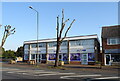
3
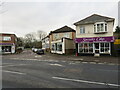
Furniture Store
This shop is on the north side of the Wimborne Rd the A341 at Kinson. It is on the junction with Truman Rd.
Image: © Nigel Mykura
Taken: 15 Nov 2011
0.05 miles
4
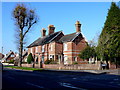
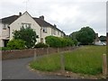
House on Wimborne Rd
This red brick Victorian detached house with a small modern extension sits at the junction with Truman Rd. The road in the foreground is the A341 Wimborne Rd.
Image: © Nigel Mykura
Taken: 15 Nov 2011
0.05 miles
5
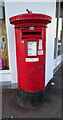
Elizabeth II postbox on Wimborne Road
Postbox No. BH11 373.
Image: © JThomas
Taken: 24 Mar 2022
0.05 miles
6
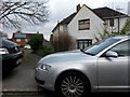
Kinson: southern end of footpath E25
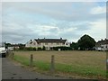
Roosevelt Crescent is a rather elongated crescent shape, turning back on itself quite sharply and with one end just along Truman Road from the other. The houses on the inside of the 180° turn do not follow the route of the road, but leave a semi-circular grass space between them and it (see Image).
The path along their frontages is designated as public footpath E25 and it is a modest 42m in length, but by no means short in comparison to some other public footpaths in the borough.
See Image for the view along the path from the other end, a view less obscured by parked cars.
Image: © Chris Downer
Taken: 18 Mar 2017
0.06 miles
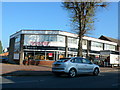
7
Oxford Lane, Kinson, near Bournemouth
Oxford Lane is a short street in Kinson, in the northern suburbs of Bournemouth.
Image: © Malc McDonald
Taken: 9 Feb 2025
0.06 miles
8
Kinson: footpath E25, Roosevelt Crescent
Roosevelt Crescent is a rather elongated crescent shape, turning back on itself quite sharply and with one end just along Truman Road from the other. The houses on the inside of the 180° turn do not follow the route of the road, but leave a semi-circular grass space between them and it (see Image).
The path along their frontages is designated as public footpath E25 and it is a modest 42m in length, but by no means short in comparison to some other public footpaths in the borough. See Image for the view from the other end, rather cluttered with parked cars.
Image: © Chris Downer
Taken: 14 Jun 2016
0.06 miles
9
Kinson: the inside bend of Roosevelt Crescent
Roosevelt Crescent is a small development of council housing forming, as its name suggests, a crescent shape - albeit an elongated one. The inside bend is thus quite sharp and it contains a small green space, while the houses around the curve are set back.
The short-cut path along the frontage of the houses is a public right of way, footpath E25, and can be seen here Image
Image: © Chris Downer
Taken: 29 Jul 2016
0.06 miles
10
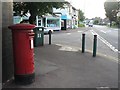
Kinson: postbox № BH11 373, Wimborne Road
This postbox stands outside Image
Image: © Chris Downer
Taken: 21 Jul 2008
0.06 miles