IMAGES TAKEN NEAR TO
Berrans Avenue, BOURNEMOUTH, BH11 9BT

Introduction

This page details the photographs taken nearby to Berrans Avenue, BH11 9BT by members of the Geograph project.

The Geograph project started in 2005 with the aim of publishing, organising and preserving representative images for every square kilometre of Great Britain, Ireland and the Isle of Man.

There are currently over 7.5m images from over14,400 individuals and you can help contribute to the project by visiting https://www.geograph.org.uk

Image Map


Images are licensed for reuse under creativecommons.org/licenses/by-sa/2.0
Notes
  • Clicking on the map will re-center to the selected point.
  • The higher the marker number, the further away the image location is from the centre of the postcode.

Image Listing (90 Images Found)

Images are licensed for reuse under creativecommons.org/licenses/by-sa/2.0
  • ...
Image
Details
Distance
1
Kinson: flooding at Millhams Mead
This little nature reserve, around a minor backwater of the River Stour, has been engulfed after very heavy rain over the weekend.
Image: © Chris Downer Taken: 9 Jul 2012
0.06 miles
2
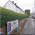
Kinson: Berrans Avenue
The end wall and frontages of the council houses in the background illustrate the nature of this road. It is quite long for a dead-end without any turnings. The sign is of a design that became prevalent in Bournemouth around 1990 and was in use for most of that decade. Many are starting to look a bit shabby now, but although this one is grubby its white surface isn't flaking and the blue border is intact. This is photo no.36 of a series of 451 in my coronavirus lockdown walking project: See https://www.geograph.org.uk/article/My-2020-Coronavirus-Lockdown-walking-project for the complete set of photos.
Image: © Chris Downer Taken: 18 Apr 2020
0.08 miles
3
Kinson: Millhams Mead floods from the churchyard
Looking across Millhams Mead, this view would normally be mainly one of grass, with a minor arm of the Stour flowing through it roughly towards us. After a weekend of heavy rain, though, it is more of a lake. See also Image
Image: © Chris Downer Taken: 9 Jul 2012
0.08 miles
4
Kinson: footpath E23 nears Berrans Avenue
Looking along the northern end of this public footpath, as it arrives at the dead end of Berrans Avenue. A cat wanders along the wall alongside. See Image for a picture from the bottom of the path ahead, and Image for the next stretch of path behind us.
Image: © Chris Downer Taken: 30 Jun 2016
0.08 miles
5
Kinson: footpath E23 arrives at Berrans Avenue
Looking across the dead end of Berrans Avenue (to our right is just the car park of a block of flats), where the public footpath from Wimborne Road comes out. See Image] for the next picture up the path.
Image: © Chris Downer Taken: 30 Jun 2016
0.08 miles
6
Kinson: footpath E23 to Berrans Avenue
To the left of the semi-detached houses can be seen a public footpath, running through to the dead end of Berrans Avenue. See Image for the next picture along the path.
Image: © Chris Downer Taken: 30 Jun 2016
0.08 miles
7
Kinson: midway along footpath E23
This public footpath, heading from Wimborne Road to Berrans Avenue, takes a secluded, rural-looking course between two tall hedges, rather belying its suburban surroundings. See Image for the next stretch of the path ahead, and Image for the next photo behind us.
Image: © Chris Downer Taken: 30 Jun 2016
0.09 miles
8
Kinson: footpath E23 arrives on Wimborne Road
This public footpath from the end of Berrans Avenue meets the main Wimborne Road. See Image] for a view down the path from across the road, and Image for the next view of the path behind us.
Image: © Chris Downer Taken: 30 Jun 2016
0.09 miles
9
Kinson: footpath E24 emerges onto Wimborne Road
This public footpath from Wakely Road leaves its wooded lower section as it opens out onto the main Wimborne Road. See Image] for a view towards us from across the road, and Image for the next picture up the path behind us. Visible in the background is the start of Image
Image: © Chris Downer Taken: 30 Jun 2016
0.10 miles
10
Path in the Millhams Mead Nature Reserve
Part of the Stour Valley Way.
Image: © David Lally Taken: 18 Sep 2010
0.10 miles
  • ...