IMAGES TAKEN NEAR TO
Lydford Gardens, BOURNEMOUTH, BH11 8TB
Introduction
This page details the photographs taken nearby to Lydford Gardens, BH11 8TB by members of the Geograph project.
The Geograph project started in 2005 with the aim of publishing, organising and preserving representative images for every square kilometre of Great Britain, Ireland and the Isle of Man.

There are currently over 7.5m images from over14,400 individuals and you can help contribute to the project by visiting https://www.geograph.org.uk
Image Map (Loading...)


Getting Data...Please wait
Leaflet Map data © OpenStreetMap
Images are licensed for reuse under creativecommons.org/licenses/by-sa/2.0
Notes
- Clicking on the map will re-center to the selected point.
- The higher the marker number, the further away the image location is from the centre of the postcode.
Image Listing (51 Images Found)
Images are licensed for reuse under creativecommons.org/licenses/by-sa/2.0
Image
Details
Distance
1
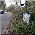
West Howe: Lydford Gardens
A cul-de-sac of Lydford Road, on the southern edge of the West Howe council estate built in the 1950s. While Lydford Road is original in that respect, Lydford Gardens is later, appearing on maps by about 1982.
The road sign is a standard one from around 2000-2006, perhaps a little earlier, featuring the borough coat of arms.
This is photo no.249 of a series of 453 in my coronavirus lockdown walking project:
See https://www.geograph.org.uk/article/My-2020-Coronavirus-Lockdown-walking-project for the complete set of photos.
Image: © Chris Downer
Taken: 18 Apr 2020
0.05 miles
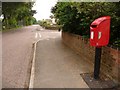
2

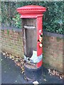
West Howe: postbox № BH11 285, Fernheath Road
The 5a bus travels past this George VI-reign postbox on Fernheath Road, at the southern edge of the large council housing estate of West Howe.
A few months later it would be vandalised and, eventually, replaced: see Image and Image
Image: © Chris Downer
Taken: 17 Aug 2008
0.07 miles
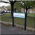
3
West Howe: replacement postbox in Fernheath Road
A little over six months after the George VI-reign Image became unusable owing to vandalism, it has now been replaced by a modern box on a pole.
See also Image
Image: © Chris Downer
Taken: 12 Jun 2009
0.07 miles
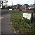
4
West Howe: Lydford Road
Looking along this road at the southern edge of the large 1950s West Howe council estate – behind us is Turbary Park Avenue which abuts the vast Turbary Common. The left-hand side of the road features the terrace visible in the background and one pair of semis, while two linked blocks of flats take up the large plot on this eastern side, with a pair of semis further down.
The sign is a modern one, from 2010-15 when this more modern, abstract emblem rather than the traditional town coat of arms as the working logo of the council.
This is photo no.250 of a series of 453 in my coronavirus lockdown walking project:
See https://www.geograph.org.uk/article/My-2020-Coronavirus-Lockdown-walking-project for the complete set of photos.
Image: © Chris Downer
Taken: 18 Apr 2020
0.07 miles
5
West Howe: Fernheath Road
Seen here coming off Turbary Park Avenue, Fernheath Road is one of the main access roads to the large West Howe council estate, especially via Verney Road which is next on the right, virtually in the picture. The bungalows at this southeast end give way to council semi-detached houses midway along.
The road sign is a standard one from around 2000-2006, perhaps a little earlier, featuring the borough coat of arms.
This is photo no.143 of a series of 453 in my coronavirus lockdown walking project:
See https://www.geograph.org.uk/article/My-2020-Coronavirus-Lockdown-walking-project for the complete set of photos.
Image: © Chris Downer
Taken: 12 Apr 2020
0.07 miles
6
West Howe: vandalised postbox
A Royal Mail notice in the bottom of Image apologises for the fact that collections have been temporarily cancelled from this point, owing to circumstances totally beyond their control. It states that the last collection from here was on 27 November and gives details of three nearby alternative boxes.
It was subsequently replaced by a modern box – see Image
Image: © Chris Downer
Taken: 7 Dec 2008
0.08 miles
7
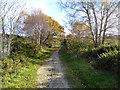
Path on Turbary Common
A public open space.
Image: © Robin Webster
Taken: 25 Nov 2016
0.10 miles
8
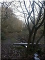
Stream, Turbary Common
Turbary Common is a jewel of countryside hemmed in by housing development & industrial estates. This stream drains the valley mire of Tussock Bog Image
Image: © Mike Faherty
Taken: 8 Dec 2008
0.12 miles
9
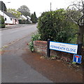
West Howe: Fernheath Close
A cul-de-sac of Fernheath Road, the latter being on the very fringe of the large West Howe council estate, unlike the bungalows here.
The sign is a modern one, from 2010-15 when this more modern, abstract emblem rather than the traditional town coat of arms as the working logo of the council. The no-through-road sign is an afterthought here, whereas it is often incorporated into the nameplate.
This is photo no.142 of a series of 453 in my coronavirus lockdown walking project:
See https://www.geograph.org.uk/article/My-2020-Coronavirus-Lockdown-walking-project for the complete set of photos.
Image: © Chris Downer
Taken: 18 Apr 2020
0.12 miles
10
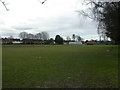
West Howe, sports ground
On Fernheath Road; pavilion to the right (East).
Image: © Mike Faherty
Taken: 21 Feb 2010
0.14 miles