IMAGES TAKEN NEAR TO
St. Marks Road, BOURNEMOUTH, BH11 8SZ
Introduction
This page details the photographs taken nearby to St. Marks Road, BH11 8SZ by members of the Geograph project.
The Geograph project started in 2005 with the aim of publishing, organising and preserving representative images for every square kilometre of Great Britain, Ireland and the Isle of Man.

There are currently over 7.5m images from over14,400 individuals and you can help contribute to the project by visiting https://www.geograph.org.uk
Image Map (Loading...)


Getting Data...Please wait
Leaflet Map data © OpenStreetMap
Images are licensed for reuse under creativecommons.org/licenses/by-sa/2.0
Notes
- Clicking on the map will re-center to the selected point.
- The higher the marker number, the further away the image location is from the centre of the postcode.
Image Listing (95 Images Found)
Images are licensed for reuse under creativecommons.org/licenses/by-sa/2.0
Image
Details
Distance
1
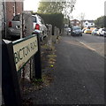
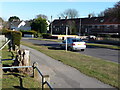
East Howe: Bicton Road
This road contains just a few houses on its short length between Kinson Road and St Mark's Road, which latter we see in the background.
The sign is a modern one, probably from around 2000, and is not rare in this neck of the woods. It morphed into a later design, including BOURNEMOUTH BOROUGH COUNCIL in smaller letters at the top, and the borough coat of arms on the left.
This is photo no.40 of a series of 451 in my coronavirus lockdown walking project:
See https://www.geograph.org.uk/article/My-2020-Coronavirus-Lockdown-walking-project for the complete set of photos.
Image: © Chris Downer
Taken: 12 Apr 2020
0.05 miles
3
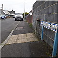
East Howe: Kinson Road
One of the most important through roads in the area, it is surprising that Kinson Road has never been classified as at least a B road, but in the 98 years of road classifications it never has. The road forms the direct route from Wallisdown into the centre of Kinson, about 2 miles, and is dead straight for the southern two thirds of this journey. It is residential for its whole length, apart from a short shopping parade and a couple of other corner shops, and the house numbers reach the mid-400s at Kinson.
The sign is of a simple design which was produced in great numbers, I believe at the back end of the 1980s, and quite a few remain. Peculiarly, Kinson Road clearly was given a large number of these signs, even facing dead-end roads which could only be accessed from here – such as this one which faces Norcliffe Close. Some are beginning to look a little tatty while others, like this one, look as good as new.
This is photo no.232 of a series of 451 in my coronavirus lockdown walking project:
See https://www.geograph.org.uk/article/My-2020-Coronavirus-Lockdown-walking-project for the complete set of photos.
Image: © Chris Downer
Taken: 14 Apr 2020
0.07 miles
4
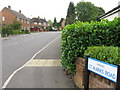
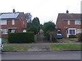
East Howe: Caroline Road
Looking along this short road of bungalows from its western end.
The road sign is a one-line version of the blue design which became prevalent in Bournemouth around 1990 and was in use for most of that decade. These narrower signs are much less common, even for road names that fit nicely on one line! (See Image for one neatly arranged on two lines, and Image for one written on one line but on a larger sign.)
Just beyond it is a concrete pillar shaped to a narrow 'T' at the top, which would undoubtedly originally have displayed an original cast-iron nameplate such as at Image
This is photo no.60 of a series of 453 in my coronavirus lockdown walking project:
See https://www.geograph.org.uk/article/My-2020-Coronavirus-Lockdown-walking-project for the complete set of photos.
Image: © Chris Downer
Taken: 18 Apr 2020
0.08 miles
5
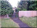
West Howe: footpath U25 from Moorside Road
The footpath goes between two houses and then heads up the steep open space on its way to Tedder Road. There is actually a more obvious path a few doors along to our left (see Image) but that is not designated as a public right of way.
See Image for the next photo on the path, with links to further photos along the route.
Image: © Chris Downer
Taken: 9 Feb 2017
0.08 miles
6
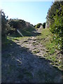
Bournemouth : Fernheath Valley & Path
A path going uphill which goes along the backs of houses on Moorside Road.
Image: © Lewis Clarke
Taken: 8 Mar 2010
0.08 miles
7
West Howe: footpath U25 approaches Moorside Road
The path has come down through a grass open space from Tedder Road and now enters an alley to finish the journey to Moorside Road.
See Image for the view towards us from the end of the path ahead, and Image for the view across the green open space behind us.
Image: © Chris Downer
Taken: 28 Jun 2016
0.09 miles
8
East Howe Youth Centre
On Kinson Road. A plaque states "Council School 1911".
Image: © Mike Faherty
Taken: 1 Mar 2010
0.09 miles
9
Bournemouth : Moorside Road
Moorside Road as it turns a corner with houses on either side of it.
Image: © Lewis Clarke
Taken: 8 Mar 2010
0.09 miles
10

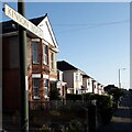
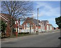
West Howe: Moorside Road
Looking at some of the semi-detached houses on this road which marks the southeastern edge of the large 1950s West Howe council estate.
The sign dates from around 1999/2000 and is one of the first to include the borough logo. It morphed from this version, one size regardless of the name length, to a similar design but with centred text, to the commonplace version with blue edges and with slightly less emboldened typeface.
This is photo no.283 of a series of 453 in my coronavirus lockdown walking project:
See https://www.geograph.org.uk/article/My-2020-Coronavirus-Lockdown-walking-project for the complete set of photos.
Image: © Chris Downer
Taken: 12 Apr 2020
0.09 miles