IMAGES TAKEN NEAR TO
Hawden Road, BOURNEMOUTH, BH11 8RP
Introduction
This page details the photographs taken nearby to Hawden Road, BH11 8RP by members of the Geograph project.
The Geograph project started in 2005 with the aim of publishing, organising and preserving representative images for every square kilometre of Great Britain, Ireland and the Isle of Man.

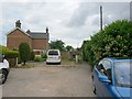
There are currently over 7.5m images from over14,400 individuals and you can help contribute to the project by visiting https://www.geograph.org.uk
Image Map
Images are licensed for reuse under creativecommons.org/licenses/by-sa/2.0
Notes
- Clicking on the map will re-center to the selected point.
- The higher the marker number, the further away the image location is from the centre of the postcode.
Image Listing (58 Images Found)
Images are licensed for reuse under creativecommons.org/licenses/by-sa/2.0
Image
Details
Distance
1
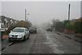
Drizzle in Bascott Road
In the Wallisdown area of Bournemouth.
Image: © David Lally
Taken: 19 Mar 2010
0.04 miles
2
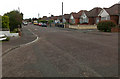
Bascott Road, Wallisdown
Mostly consisting of small detached bungalows. My guess would be late 1940s or early 1950s construction.
Image: © David Lally
Taken: 20 Sep 2009
0.05 miles
3
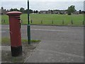
Wallisdown: postbox № BH11 44, Canford Avenue
Looking across the football field beyond.
Image: © Chris Downer
Taken: 17 Aug 2008
0.09 miles
4
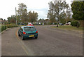
Bascott Road, Wallisdown
Turning north towards the edge of Turbary Common.
Image: © David Lally
Taken: 20 Sep 2009
0.09 miles
5
Wallisdown: southern end of footpath U16
This public footpath is long and straight, running from Canford Avenue to Bascott Road. It has several stretches which are access to rear driveways, and even some parts which are the main, front access to houses that have been built in a rather higgledy-piggledy arrangement between the various roads hereabouts.
Here, we see it arrive at the dead end of Bascott Road. A little offshoot extends from the dead end, called Bascott Close, ahead and footpath U15 continues to Wallisdown Road from the right of the caravan.
See Image for the next view on path U16, behind us, and Image for the next view on the path U15 ahead - each with links to further photos along that route.
Image: © Chris Downer
Taken: 12 Jul 2016
0.10 miles
6
Wallisdown: footpath U16 nears Bascott Road
This public footpath is long and straight, running from Canford Avenue to Bascott Road. It has several stretches which are access to rear driveways, and even some parts which are the main, front access to houses that have been built in a rather higgledy-piggledy arrangement between the various roads hereabouts.
Here, we see it approach its southern end, at the dead end of Bascott Road. A little offshoot extends from the dead end, called Bascott Close, in the background and a continuing path goes to Wallisdown Road from the right of the distant caravan.
See Image for the next view on the path ahead, and Image for the next view on the path behind us - each with links to further photos along the route.
Image: © Chris Downer
Taken: 12 Jul 2016
0.10 miles
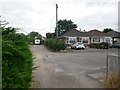
7
Wallisdown: footpath U16 passes Hawden Road
This public footpath is long and straight, running from Canford Avenue to Bascott Road. It has several stretches which are access to rear driveways, and even some parts which are the main, front access to houses that have been built in a rather higgledy-piggledy arrangement between the various roads hereabouts.
Here, we see Hawden Road as the route passes its dead end - unusually, the numbering starts at the dead end, with number 1 alongside us. The path in each direction from here forms a driveway to a few houses.
See Image for the next view on the path ahead, and Image for the view behind us from just ahead - each with links to further photos along that route.
Image: © Chris Downer
Taken: 12 Jul 2016
0.10 miles
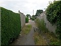
8
Wallisdown: sign for concealed houses on footpath U16
This public footpath is long and straight, running from Canford Avenue to Bascott Road. It has several stretches which are access to rear driveways, and even some parts which are the main, front access to houses that have been built in a rather higgledy-piggledy arrangement between the various roads hereabouts.
Here, we see the route heading southward from the dead end of Hawden Road. The sign points the way to numbers 27, 33, 35 and 37 Canford Road - a road not even directly linked to Hawden Road.
See Image for the next view on the path ahead, and Image for the view behind us from just ahead - each with links to further photos along that route.
Image: © Chris Downer
Taken: 12 Jul 2016
0.10 miles
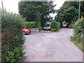
9
Wallisdown: footpath U16 forms a wide driveway
This public footpath is long and straight, running from Canford Avenue to Bascott Road. It has several stretches which are access to rear driveways, and even some parts which are the main, front access to houses that have been built in a rather higgledy-piggledy arrangement between the various roads hereabouts.
Here, we look along part of the path where it serves as a particularly wide driveway - big enough to turn a vehicle round - outside several houses which do not abut the road. It continues along the narrow path ahead.
See Image for the next view on the path ahead, and Image for the next view on the path behind us - each with links to further photos along the mentioned routes.
Image: © Chris Downer
Taken: 12 Jul 2016
0.11 miles
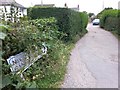
10
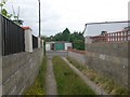
Wallisdown: western end of footpath U18
This public footpath is essentially a rear garage driveway for houses in Canford Avenue and Walliscott Road. Given the height of the grass down the middle, it is perhaps not very heavily used as a driveway.
See Image for the view along the driveway from across the road, and Image for the next view behind us.
Image: © Chris Downer
Taken: 12 Jul 2016
0.11 miles