IMAGES TAKEN NEAR TO
Mandale Road, BOURNEMOUTH, BH11 8HZ
Introduction
This page details the photographs taken nearby to Mandale Road, BH11 8HZ by members of the Geograph project.
The Geograph project started in 2005 with the aim of publishing, organising and preserving representative images for every square kilometre of Great Britain, Ireland and the Isle of Man.

There are currently over 7.5m images from over14,400 individuals and you can help contribute to the project by visiting https://www.geograph.org.uk
Image Map (Loading...)


Getting Data...Please wait
Leaflet Map data © OpenStreetMap
Images are licensed for reuse under creativecommons.org/licenses/by-sa/2.0
Notes
- Clicking on the map will re-center to the selected point.
- The higher the marker number, the further away the image location is from the centre of the postcode.
Image Listing (62 Images Found)
Images are licensed for reuse under creativecommons.org/licenses/by-sa/2.0
Image
Details
Distance
1
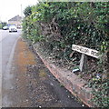
West Howe: Batchelor Road
Batchelor Road is on the large 1950s West Howe council estate and comprises mainly those easily recognisable council semis. They are not very visible here but see Image for nearby examples.
Surprisingly, Batchelor Road still possesses three of its four original nameplates, embossed in cast iron and still on their original single concrete legs. The leg continues behind the sign at half depth and splays into a T shape, where the sign is attached. (See Image] for an example of an old post, minus its sign.)
(One might say, rather meanly, all the more surprising because 30 years ago West Howe had quite a reputation for deprivation, vandalism and antisocial behaviour.)
This is photo no.32 of a series of 451 in my coronavirus lockdown walking project:
See https://www.geograph.org.uk/article/My-2020-Coronavirus-Lockdown-walking-project for the complete set of photos.
Image: © Chris Downer
Taken: 18 Apr 2020
0.06 miles
2
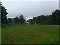
West Howe: small playpark alongside Turbary Park Avenue
A small playing field, with short, sturdy metal goalposts, and a well-equipped, fully cordoned children's play area in the background. Turbary Park Avenue runs along the left-hand side, while there are three entrances to the park: from Mandale Road (in the distance), Kimber Road (behind us) and Frost Road (through a wide gap in the houses to the left).
We visit it now on a drizzly summer's evening at about 8:30; little surprise that it isn't busy!
Image: © Chris Downer
Taken: 10 Aug 2009
0.08 miles
3
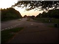
West Howe: Mandale Road meets Turbary Park Avenue
We look along the western end of Turbary Park Avenue, where Mandale Road comes out from the large council estate of West Howe. Apart from Turbary Park Avenue (which is named after Turbary Common alongside) and the other original thoroughfares, the roads on the West Howe estate are named after local heroes from the Second World War.
Image: © Chris Downer
Taken: 11 May 2009
0.08 miles
4
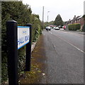
West Howe: Hall Road
Hall Road is on the western edge of the large, 1950s West Howe council estate and is also at the very edge of my 2km radius from home: my circumference line cuts through the road perhaps a little over halfway down from this end.
The sign is a modern one, from 2010-15 when this more modern, abstract emblem rather than the traditional town coat of arms as the working logo of the council.
This is photo no.164 of a series of 453 in my coronavirus lockdown walking project:
See https://www.geograph.org.uk/article/My-2020-Coronavirus-Lockdown-walking-project for the complete set of photos.
Image: © Chris Downer
Taken: 18 Apr 2020
0.09 miles
5
Driveway to garages
Between Turbary Park Avenue and Maclean Road, this drive provides vehicle access (complete with speed-bumps) to the rear gardens most of which are in an interesting state of disrepair.
Image: © David Lally
Taken: 1 Jul 2010
0.10 miles
6
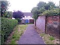
West Howe: footpath U01 meets the rear driveway
Looking along this public footpath from Turbary Park Avenue as it approaches a rear garage driveway. The route of the footpath turns to the right, heading for Maclean Road.
See Image for the next view along the path ahead, with links to further photos on the route, and Image for the view behind us from here.
Image: © Chris Downer
Taken: 12 Jul 2016
0.10 miles
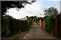
7
West Howe: footpath U08 from Mandale Road
This public footpath is lined by a wide grassed area and leads through to Maclean Road.
Many of the footpaths on the West Howe estate and thereabouts have been given names in the last couple of years, a safety initiative whose intention is that, in the event of calling for help, one's location can be more easily described. This one has been named Heathlands Walk, after the primary school serving the estate, just a minute's walk beyond the end of the path (see Image).
See Image for a view towards us from beyond the wall.
Image: © Chris Downer
Taken: 30 Jun 2016
0.11 miles
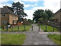
8
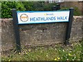
West Howe: sign on Heathlands Walk
This public footpath is lined by a wide grassed area and leads through to Maclean Road.
Many of the footpaths on the West Howe estate and thereabouts have been given names in the last couple of years, a safety initiative whose intention is that, in the event of calling for help, one's location can be more easily described. This one has been named Heathlands Walk, after the primary school serving the estate, just a minute's walk beyond the end of the path. The sign incorporates the logo of the school.
See Image for a view along the path, with this sign on the left.
Image: © Chris Downer
Taken: 30 Jun 2016
0.11 miles
9
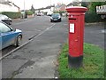
West Howe: postbox № BH11 71, Maclean Road
This Elizabeth II-reign postbox, at the corner of a grassy patch between road and houses, is emptied finally at 5:30pm on weekdays and at 12:30pm on Saturdays.
Image: © Chris Downer
Taken: 7 Dec 2008
0.11 miles
10
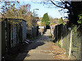
Back alley
The back gardens of houses on Turbary Park Avenue on the left, and of MacLean Road on the right.
Image: © Robin Webster
Taken: 25 Nov 2016
0.11 miles