IMAGES TAKEN NEAR TO
Maclean Road, BOURNEMOUTH, BH11 8ER
Introduction
This page details the photographs taken nearby to Maclean Road, BH11 8ER by members of the Geograph project.
The Geograph project started in 2005 with the aim of publishing, organising and preserving representative images for every square kilometre of Great Britain, Ireland and the Isle of Man.

There are currently over 7.5m images from over14,400 individuals and you can help contribute to the project by visiting https://www.geograph.org.uk
Image Map (Loading...)


Getting Data...Please wait
Leaflet Map data © OpenStreetMap
Images are licensed for reuse under creativecommons.org/licenses/by-sa/2.0
Notes
- Clicking on the map will re-center to the selected point.
- The higher the marker number, the further away the image location is from the centre of the postcode.
Image Listing (74 Images Found)
Images are licensed for reuse under creativecommons.org/licenses/by-sa/2.0
Image
Details
Distance
1
West Howe: footpath U02 behind Turbary Park Avenue
This public footpath comes along the driveway access from Turbary Park Avenue, left, onto the rear driveway itself. The route of the footpath then goes ahead towards an alley to Maclean Road, part of footpath U01.
See Image for the view from Turbary Park Avenue (left), and Image for the next view on the route ahead, with links to further pictures along the path.
Image: © Chris Downer
Taken: 12 Jul 2016
0.03 miles
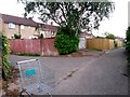
2
Driveway between Turbary Park Avenue and Maclean Road
Someone has stored two traffic cones on a gate-less gatepost.
Image: © David Lally
Taken: 1 Jul 2010
0.03 miles
3
West Howe: this driveway is footpath U02
Looking along a rear access driveway between Turbary Park Avenue (right) and Maclean Road (left).
Public footpath U01 comes up from Maclean Road onto the driveway and one has two choices: turn right to continue along path U01 to arrive on Turbary Park Avenue, or come this way, turning left to arrive further along.
See Image for the next view along the route ahead, and Image] for the view behind us - each with links to further photos on the mentioned routes.
Image: © Chris Downer
Taken: 12 Jul 2016
0.04 miles
4
West Howe: footpath U02 from Turbary Park Avenue
This driveway, which turns left and right ahead leading to rear garages, forms the start of public footpath U02. The route of the footpath is to the left, following the driveway until it meets the alleyway to Maclean Road, part of path U01.
See Image for the next view along the route, with links to further pictures along the course of the footpath.
Image: © Chris Downer
Taken: 12 Jul 2016
0.04 miles
5
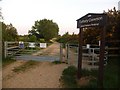
West Howe: an entrance to Turbary Common
One of numerous paths onto Turbary Common, I guess this would be regarded as one of the main ones, since it provides a gravelled path across the common to Downey Close on the south side. The path is a shared foot and cycle route, and the kissing gate is large enough that a cycle could be negotiated through it fairly easily.
Image: © Chris Downer
Taken: 11 May 2009
0.05 miles
6
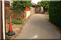
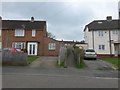
West Howe: footpath U01 arrives at Maclean Road
The eastern end of this public footpath from Turbary Park Avenue. The semi-detached houses on Maclean Road are typical of this large council estate.
See Image for the view towards us from across the road, and Image for the view down the path from behind us, with links to further photos along the route.
Image: © Chris Downer
Taken: 12 Jul 2016
0.05 miles
7
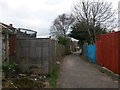
West Howe: footpath U02 swings a bit to the right
This rear access driveway is also the route of a public footpath, number U02, which heads from Turbary Park Avenue towards Maclean Road. It is actually another public footpath, which comes from further along Turbary Park Avenue, which comes towards us ahead on the same driveway before heading down the alley to Maclean Road.
See Image for the view behind us, with links to further photos along path U02; and Image for the next view on the path ahead, with links to further photos on path U01.
Image: © Chris Downer
Taken: 18 Mar 2017
0.05 miles
8
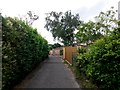
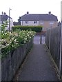
West Howe: footpath U01 from Maclean Road
This little alleyway reaches the driveway running behind the houses. The route of the public footpath then splits - footpath U01 turns right onto the driveway, then left to meet Turbary Park Avenue; while one could turn left along the driveway, then right, on the route numbered U02 to meet Turbary Park Avenue a bit further along.
See Image for the view towards us from a little way up the path, with links to further photos on the mentioned routes.
Image: © Chris Downer
Taken: 18 Mar 2017
0.05 miles
9
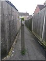
West Howe: footpath U01 nears Maclean Road
This public footpath has left the rear driveway behind us, and now heads down a short alley onto Maclean Road.
See Image for the emergence on the road ahead, and Image for the next view behind us, with links to further photos along the driveway.
Image: © Chris Downer
Taken: 12 Jul 2016
0.05 miles
10
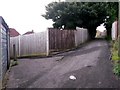
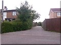
West Howe: footpaths U01 and U02 meet
Looking along the rear garage driveway between Turbary Park Avenue (right) and Maclean Road. Public footpath U01 comes up the alleyway from Maclean Road (left), and goes along the driveway behind us to take a similar offshoot path to Turbary Park Avenue.
Meanwhile, the driveway ahead forms the start of footpath U02, which likewise turns right onto Turbary Park Avenue.
See:
Image for a view down the alley to the left;
Image for the next view along the driveway behind us; and
Image for the view towards us on path U02 ahead.
Each link has further links to photos along the route.
Image: © Chris Downer
Taken: 12 Jul 2016
0.06 miles