IMAGES TAKEN NEAR TO
Mount Road, BOURNEMOUTH, BH11 8BH
Introduction
This page details the photographs taken nearby to Mount Road, BH11 8BH by members of the Geograph project.
The Geograph project started in 2005 with the aim of publishing, organising and preserving representative images for every square kilometre of Great Britain, Ireland and the Isle of Man.

There are currently over 7.5m images from over14,400 individuals and you can help contribute to the project by visiting https://www.geograph.org.uk
Image Map (Loading...)


Getting Data...Please wait
Leaflet Map data © OpenStreetMap
Images are licensed for reuse under creativecommons.org/licenses/by-sa/2.0
Notes
- Clicking on the map will re-center to the selected point.
- The higher the marker number, the further away the image location is from the centre of the postcode.
Image Listing (101 Images Found)
Images are licensed for reuse under creativecommons.org/licenses/by-sa/2.0
Image
Details
Distance
1
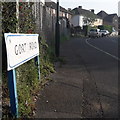
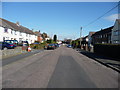
West Howe: Gort Road
A short, squiggly road in the heart of the large 1950s West Howe council estate – it comes off the centrepiece, Cunningham Crescent, although we are looking at it from the other end, on Mount Road.
The sign is of a design that became prevalent in Bournemouth around 1990 and was in use for most of that decade. Many are starting to look a bit shabby now, the blue border fading and the white surface unpeeling, but this one is in pretty good condition.
This is photo no.169 of a series of 453 in my coronavirus lockdown walking project:
See https://www.geograph.org.uk/article/My-2020-Coronavirus-Lockdown-walking-project for the complete set of photos.
Image: © Chris Downer
Taken: 12 Apr 2020
0.06 miles
2
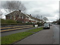
West Howe, Montgomery Avenue
1960s-looking houses on the eastern side of West Howe Estate.
Image: © Mike Faherty
Taken: 21 Feb 2010
0.10 miles
3
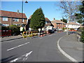
Bournemouth : Gort Road & Roadworks
These workmen are busy and they have some lovely weather to help them work.
Image: © Lewis Clarke
Taken: 8 Mar 2010
0.11 miles
4

Bournemouth : Cunningham Crescent Bus Stop
The 5b bus picks up some passengers. Soon after this photograph I was approached by two teenage girls who wanted a fag and wondered if I had any.
Image: © Lewis Clarke
Taken: 8 Mar 2010
0.11 miles
5
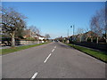
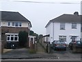
Bournemouth : Montgomery Avenue
If you follow this road all the way from here at Cunningham Crescent, to the end, you'll end up on Kinson Road.
Image: © Lewis Clarke
Taken: 8 Mar 2010
0.12 miles
6

West Howe: postbox № BH11 67, Rochester Road
This small postbox is on the corner of Rochester and Ritchie Roads. The surrounding semi-detached houses are typical of this large council estate.
Image: © Chris Downer
Taken: 17 Aug 2008
0.12 miles
7
Bournemouth : Tedder Road
Tedder Road is another road in Kinson which has residential houses on it.
Image: © Lewis Clarke
Taken: 8 Mar 2010
0.12 miles
8
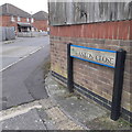
West Howe: Hanlon Close
Hanlon Close comes off Grower Gardens, both dead ends for vehicles, and are two of relatively few roads to have been added to the large West Howe council estate since it was built in the 1950s.
They are built on the site of the old Heathlands First School, which closed in around 1993 when it amalgamated with Heathlands Junior to become an all-through primary school, and was all accommodated on the Junior site. The school buildings were destroyed by fire shortly after closure and before official demolition was due.
The sign is an early version of a standard Bournemouth design from around 2000, the early version recognisable by a slightly more emboldened typeface, aligned to the left when on two lines or, never on the newer versions, written on a single line as here.
This is photo no.180 of a series of 453 in my coronavirus lockdown walking project:
See https://www.geograph.org.uk/article/My-2020-Coronavirus-Lockdown-walking-project for the complete set of photos.
Image: © Chris Downer
Taken: 18 Apr 2020
0.13 miles
9
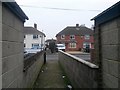
West Howe: footpath U25 arrives at Tedder Road
The footpath from Moorside Road has come up the steep open space and now emerges from between two houses onto Tedder Road.
See Image for the view towards us, and Image for the next view on the path behind, with links to further photos along the route.
Image: © Chris Downer
Taken: 9 Feb 2017
0.13 miles
10
West Howe: footpath U25 from Tedder Road
Looking across Tedder Road along this public footpath which, beyond the alley, heads steeply down a small open space to Moorside Road.
See Image for the next view along the path, with links to further photos on the route.
Image: © Chris Downer
Taken: 9 Feb 2017
0.14 miles