IMAGES TAKEN NEAR TO
New Road, BOURNEMOUTH, BH10 7DW
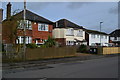
Introduction
This page details the photographs taken nearby to New Road, BH10 7DW by members of the Geograph project.
The Geograph project started in 2005 with the aim of publishing, organising and preserving representative images for every square kilometre of Great Britain, Ireland and the Isle of Man.

There are currently over 7.5m images from over14,400 individuals and you can help contribute to the project by visiting https://www.geograph.org.uk
Image Map
Images are licensed for reuse under creativecommons.org/licenses/by-sa/2.0
Notes
- Clicking on the map will re-center to the selected point.
- The higher the marker number, the further away the image location is from the centre of the postcode.
Image Listing (55 Images Found)
Images are licensed for reuse under creativecommons.org/licenses/by-sa/2.0
Image
Details
Distance
1
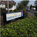
Northbourne: Greenacres Close
The sign stands on a triangle between the 45º-angle pavement turning into the road, and the main pavement of New Road on which we stand. Well-to-do bungalows are the order of the day here; the road turns 90º to the left ahead, to run parallel with the River Stour, and the gardens of the bungalows along the back edge run right down to the riverbank.
The sign is a modern one, from 2010-15 when this more modern, abstract emblem rather than the traditional town coat of arms as the working logo of the council. The no-through-road sign is incorporated into the nameplate.
This is photo no.173 of a series of 453 in my coronavirus lockdown walking project:
See https://www.geograph.org.uk/article/My-2020-Coronavirus-Lockdown-walking-project for the complete set of photos.
Image: © Chris Downer
Taken: 12 Apr 2020
0.03 miles
2
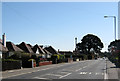
New Road, Ensbury
The A347 New Road between West Parley and Red Hill at Ensbury.
Image: © Peter Kazmierczak
Taken: 28 Mar 2012
0.03 miles
3
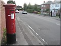
Northbourne: postbox № BH10 283, Kinson Park Road
Looking west along Kinson Park Road past this George V-reign postbox.
Image: © Chris Downer
Taken: 21 Jul 2008
0.07 miles
4
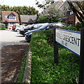
Kinson: Keeble Crescent
Keeble Crescent is a curious name: It is indeed a crescent-shaped road off Keeble Road, but according to some maps only the offshoots leading to the houses are named Keeble Crescent, the actual crescent being part of Keeble Road.
The estate dates from the later 1980s on the site of a sports ground or similar.
This is photo no.218 of a series of 453 in my coronavirus lockdown walking project:
See https://www.geograph.org.uk/article/My-2020-Coronavirus-Lockdown-walking-project for the complete set of photos.
Image: © Chris Downer
Taken: 12 Apr 2020
0.08 miles
6
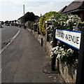
Northbourne: Avebury Avenue
Looking along this short, curved road of desirable bungalows (although there's a house visible also) from its northeast corner.
The road sign dates from 2017/2018: until then, the signage included the words BOURNEMOUTH BOROUGH COUNCIL in smaller type at the top. (Bournemouth Council ceased to exist in April 2019 but the removal of the council name happened before that).
This is photo no.22 of a series of 451 in my coronavirus lockdown walking project:
See https://www.geograph.org.uk/article/My-2020-Coronavirus-Lockdown-walking-project for the complete set of photos.
Image: © Chris Downer
Taken: 12 Apr 2020
0.09 miles
7
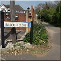
Northbourne: Brecon Close
Really a minor lane leading down to the river Stour from New Road, and containing a few bungalows further down, Brecon Close is heavily used by walkers as it leads to the start of the Bournemouth stretch of the Stour Valley Way, the riverside path leading eventually down to Christchurch Harbour.
The sign is a modern one, dating from around 2014-15, by which time the council had replaced the coloured logo, which had been prone to fading after a while, to simple wording BOURNEMOUTH BOROUGH COUNCIL in smaller type.
This is photo no.47 of a series of 453 in my coronavirus lockdown walking project:
See https://www.geograph.org.uk/article/My-2020-Coronavirus-Lockdown-walking-project for the complete set of photos.
Image: © Chris Downer
Taken: 12 Apr 2020
0.10 miles
8
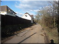
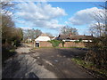
Bournemouth : Brecon Close
This road leads to the nature reserve and a nice house with a gate.
Image: © Lewis Clarke
Taken: 11 Feb 2010
0.10 miles
9
Bournemouth : Brecon Close
A nice house with a gate at the end of the road. There is a path leading left and a path leading right - both end up in the nature park.
Image: © Lewis Clarke
Taken: 11 Feb 2010
0.11 miles
10
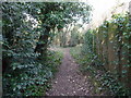
Bournemouth : Public Footpath
A footpath beside a house leading to Stour Nature Reserve.
Image: © Lewis Clarke
Taken: 11 Feb 2010
0.12 miles