IMAGES TAKEN NEAR TO
Heads Farm Close, BOURNEMOUTH, BH10 7DF
Introduction
This page details the photographs taken nearby to Heads Farm Close, BH10 7DF by members of the Geograph project.
The Geograph project started in 2005 with the aim of publishing, organising and preserving representative images for every square kilometre of Great Britain, Ireland and the Isle of Man.

There are currently over 7.5m images from over14,400 individuals and you can help contribute to the project by visiting https://www.geograph.org.uk
Image Map
Images are licensed for reuse under creativecommons.org/licenses/by-sa/2.0
Notes
- Clicking on the map will re-center to the selected point.
- The higher the marker number, the further away the image location is from the centre of the postcode.
Image Listing (79 Images Found)
Images are licensed for reuse under creativecommons.org/licenses/by-sa/2.0
Image
Details
Distance
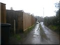
1
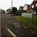
Northbourne: Heads Farm Close
You could not tell from this picture that Heads Farm Close is accessed from a narrow gravel track! But it is – it is an offshoot of Heads Lane, which is a little track-like road off Wimborne Road.
The sign is the standard Bournemouth nameplate from the 1980s, affixed with tubular steel which protrudes at each side.
This is photo no.183 of a series of 453 in my coronavirus lockdown walking project:
See https://www.geograph.org.uk/article/My-2020-Coronavirus-Lockdown-walking-project for the complete set of photos.
Image: © Chris Downer
Taken: 13 Apr 2020
0.01 miles
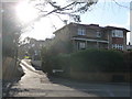
2
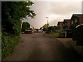
Northbourne: looking up Heads Lane to Heads Farm Close
This little lane, Heads Lane, forms a public footpath, number O21, from Wimborne Road just behind us and continuing to the left (on a gravelled surface) just behind the hedge.
Ahead of us, the little cul-de-sac of houses seems rather urban, with its wider, tarmacked surface and proper pavements, compared with its only approach along this leafy lane.
See Image for a view from the continuing Heads Lane around to the left, and Image for the view up here from Wimborne Road.
Image: © Chris Downer
Taken: 22 Jun 2016
0.02 miles
3
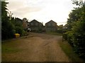
Northbourne: Heads Farm Close from the east
Looking along the top segment of the gravelled Heads Lane, before it turns right back down to Wimborne Road. Ahead of us, and proceeding just a short distance to the left, runs Heads Farm Close, almost incongruously ordinary as a tarmacked road with proper pavements. See Image for more direct view of the Close.
This segment of Heads Lane, and its continuation ahead of us, forms public footpath O21, but this becomes footpath O20 further behind us - see Image
Image: © Chris Downer
Taken: 22 Jun 2016
0.02 miles
4
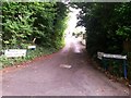
Northbourne: western end of Heads Lane
Looking from the once main Wimborne Road (this stretch is now bypassed) up Heads Lane, which goes up the hill and turns left, coming back out on Wimborne Road a little further along (see Image).
Heads Lane also forms public footpath O21 at this end, joining up with footpath O20 which starts at the other end. See Image for a view up from a short distance ahead of us.
Image: © Chris Downer
Taken: 22 Jun 2016
0.03 miles
5
Northbourne: Heads Lane forms footpaths O20 and O21
Looking along Heads Lane in a short, heavy hailstorm. The route forms a public right of way which is numbered O20 to this point from behind us - that route turns left along the alleyway to Headswell Gardens here. Meanwhile the continuing lane is numbered footpath O21.
See:
Image for the view from behind towards us;
Image for the view along the alley, left; and
Image for the next view on the lane ahead.
Each has links to further photos along the routes.
Image: © Chris Downer
Taken: 5 Mar 2017
0.03 miles
6
Northbourne: the top of Heads Lane
This is a short gravel road, coming out onto Wimborne Road at both ends. Here, we look at it about halfway along, where it forms public footpath O20 to Headswell Gardens, turning left just by the two black wheelie bins. The continuation of Heads Lane forms a different public footpath, numbered O21.
See Image] for the view down to Wimborne Road behind us, and
Image] for the next view ahead, with links to further photos in all mentioned directions.
Image: © Chris Downer
Taken: 22 Jun 2016
0.04 miles
7
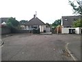
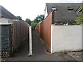
Northbourne: the dead end of Headswell Gardens
This turning space is more of a truncated T shape than a circle that might be expected. Between the two end bungalows is a footpath: Image
Image: © Chris Downer
Taken: 22 Jun 2016
0.04 miles
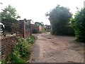
8
Bournemouth : Heads Lane & House
A house at the bottom of Heads Lane and Wimborne Road.
Image: © Lewis Clarke
Taken: 11 Feb 2010
0.04 miles
9
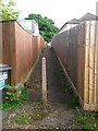
Northbourne: footpath O20 heads for Heads Lane
Looking from Image along this public footpath which heads between two bungalows onto Heads Lane. Public footpath O20 turns right at the bottom to continue down to Wimborne Road, while a left turn is also a public footpath, numbered O21, also leading to Wimborne Road.
See Image] for a view up the path, whose description contains links to further views in each direction along Heads Lane.
Image: © Chris Downer
Taken: 22 Jun 2016
0.05 miles
10
Northbourne: footpath O20 heads for Headswell Gardens
A continuation of the right of way, public footpath O20, seen behind us at Image, it takes the form of a narrow alleyway up to the dead end of Headswell Gardens. See Image for the downward view from the other end.
Image: © Chris Downer
Taken: 22 Jun 2016
0.05 miles