IMAGES TAKEN NEAR TO
Howton Close, BOURNEMOUTH, BH10 5LW
Introduction
This page details the photographs taken nearby to Howton Close, BH10 5LW by members of the Geograph project.
The Geograph project started in 2005 with the aim of publishing, organising and preserving representative images for every square kilometre of Great Britain, Ireland and the Isle of Man.

There are currently over 7.5m images from over14,400 individuals and you can help contribute to the project by visiting https://www.geograph.org.uk
Image Map
Images are licensed for reuse under creativecommons.org/licenses/by-sa/2.0
Notes
- Clicking on the map will re-center to the selected point.
- The higher the marker number, the further away the image location is from the centre of the postcode.
Image Listing (133 Images Found)
Images are licensed for reuse under creativecommons.org/licenses/by-sa/2.0
Image
Details
Distance
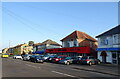
1
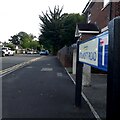
Kinson: Howton Close
A very short cul-de-sac of bungalows of Howton Road, which is itself a dead end.
The sign is a modern one, from 2010-15 when this more modern, abstract emblem rather than the traditional town coat of arms as the working logo of the council.
This is photo no.208 of a series of 453 in my coronavirus lockdown walking project:
See https://www.geograph.org.uk/article/My-2020-Coronavirus-Lockdown-walking-project for the complete set of photos.
Image: © Chris Downer
Taken: 10 Apr 2020
0.03 miles
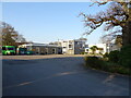
2
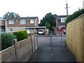
Kinson: footpath E49 crosses the Conservative Club car park
This public footpath heads from Wimborne Road to Howton Road and Leybourne Avenue, and almost immediately crosses the car park access within the Conservative Club grounds. I have a feeling that the Club has only acquired the car park in relatively recent years, as it has a fairly large frontage car park anyway.
See Image for the start of the path behind us, and Image for the next picture ahead.
Image: © Chris Downer
Taken: 24 Jun 2016
0.03 miles
3
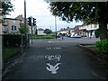
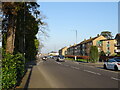
Kinson: footpath E49 arrives on Wimborne Road
This public footpath, from Leybourne Avenue and Howton Road, arrives at its northern end on the main Wimborne Road. Kinson Grove is opposite.
The pedestrian crossing, just to the left of the path's emergence, was installed in the last year or so.
It appears that this northern segment of the path has been made a shared foot/cycle path.
See Image for the path behind us.
Image: © Chris Downer
Taken: 24 Jun 2016
0.03 miles
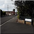
4
Kinson: Howton Road
A short dead-end road off Kitscroft Road, almost at the dead end of the latter. On a map, the road layout of these few roads looks as if more was planned but never built. The bungalows on the right back onto a portion of Kinson Common, still open public land.
The sign is a modern one, from 2010-15 when this more modern, abstract emblem rather than the traditional town coat of arms as the working logo of the council. It is quite surprising that there is even a sign on this side of the junction, since it is only visible to those approaching from the dead end of Kitscroft Road. The more useful one on the other side, visible to the motorist arriving here from the whole of the rest of the world, adds 'leading to Howton Close'.
This is photo no.209 of a series of 453 in my coronavirus lockdown walking project:
See https://www.geograph.org.uk/article/My-2020-Coronavirus-Lockdown-walking-project for the complete set of photos.
Image: © Chris Downer
Taken: 10 Apr 2020
0.04 miles
6
Kinson: footpath E49 crosses Howton Road
Looking along this footpath from Wimborne Road to Leybourne Avenue as it crosses the one intervening road, Howton Road.
Maps mark the path as running uninterrupted across the road, rather than as two separate paths, as seems to be the norm. Perhaps this indicates that the right of way existed before the road was built.
See Image for the next picture ahead, and Image for the next picture behind us.
Image: © Chris Downer
Taken: 24 Jun 2016
0.05 miles
7
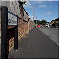
Kinson: Kitscroft Road
At the eastern end of Kinson's main shops is Kitscroft Road, a short cul-de-sac which leads to several other roads, all of whose only access is via here. From satellite images, the little development looks almost unfinished, with a number of rather abrupt dead ends that look as if there was once an intention that development go further. At the end of Kitscroft Road, there is access onto Duke's Coppice and that small detached part of Kinson Common, which remains public open space.
The sign is a modern one, from 2010-15 when this more modern, abstract emblem rather than the traditional town coat of arms as the working logo of the council. The no-through-road sign incorporated into the nameplate is a common arrangement.
This is photo no.233 of a series of 453 in my coronavirus lockdown walking project:
See https://www.geograph.org.uk/article/My-2020-Coronavirus-Lockdown-walking-project for the complete set of photos.
Image: © Chris Downer
Taken: 10 Apr 2020
0.05 miles
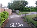
9
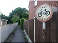
Kinson: no cycling sign on footpath E49
Looking along the southern segment of this public footpath, from Howton Road towards Leybourne Avenue. By contrast, the northern segment appears to allow cycling: see Image
See Image for the next picture ahead of us, Image for the next picture behind.
Image: © Chris Downer
Taken: 24 Jun 2016
0.06 miles