
IMAGES TAKEN NEAR TO
Green Lane, BOURNEMOUTH, BH10 5LE
Introduction
This page details the photographs taken nearby to Green Lane, BH10 5LE by members of the Geograph project.
The Geograph project started in 2005 with the aim of publishing, organising and preserving representative images for every square kilometre of Great Britain, Ireland and the Isle of Man.

There are currently over 7.5m images from over14,400 individuals and you can help contribute to the project by visiting https://www.geograph.org.uk
Image Map
Images are licensed for reuse under creativecommons.org/licenses/by-sa/2.0
Notes
- Clicking on the map will re-center to the selected point.
- The higher the marker number, the further away the image location is from the centre of the postcode.
Image Listing (54 Images Found)
Images are licensed for reuse under creativecommons.org/licenses/by-sa/2.0
Image
Details
Distance
1
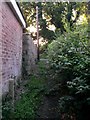
East Howe: footpath U40 comes out on Green Lane
This public footpath leads from Green Lane to Heather Road. It is a narrow, grass/earth track which is quite overgrown in places. Perhaps it is little used because a much better, tarmacked path runs parallel 100 yards or so to the south.
See Image for the view towards us from across the road, and Image for the next view along the path behind us.
Image: © Chris Downer
Taken: 3 Jul 2016
0.04 miles
2
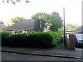
East Howe: footpath U40 to Heather Road
This public footpath leads from Green Lane to Heather Road. It is a narrow, grass/earth track which is quite overgrown. Perhaps it is little used because a much better, tarmacked path runs parallel 100 yards or so to the south.
See Image for the next view along the path.
Image: © Chris Downer
Taken: 3 Jul 2016
0.04 miles
3
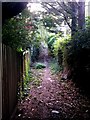
East Howe: down and up again on footpath U40
This public footpath leads from Green Lane (ahead) to Heather Road. It is a narrow, grass/earth track which is quite overgrown in places. Perhaps it is little used because a much better, tarmacked path runs parallel 100 yards or so to the south.
See Image for the next view along the path ahead, and Image for the next view behind us.
Image: © Chris Downer
Taken: 3 Jul 2016
0.04 miles
4
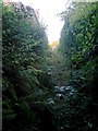
East Howe: overgrowing undergrowth on footpath U40
This public footpath leads from Green Lane (behind us) to Heather Road. It is a narrow, grass/earth track which is quite overgrown in places. Perhaps it is little used because a much better, tarmacked path runs parallel 100 yards or so to the south.
See Image for the next view along the path ahead, and Image for the next view behind us.
Image: © Chris Downer
Taken: 3 Jul 2016
0.04 miles
5
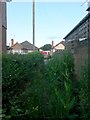
East Howe: footpath U40 approaches Heather Road
This public footpath leads from Green Lane to Heather Road. It is a narrow, grass/earth track which is quite overgrown in places. Perhaps it is little used because a much better, tarmacked path runs parallel 100 yards or so to the south.
See Image for the next view along the path ahead, and Image for the next view behind us.
Image: © Chris Downer
Taken: 3 Jul 2016
0.05 miles
6
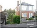
East Howe: footpath U40 from Heather Road
This public footpath leads from Heather Road to Green Lane. It is a narrow, grass/earth track which is quite overgrown in places. Perhaps it is little used because a much better, tarmacked path runs parallel 100 yards or so to the south.
See Image for the next view along the path.
Image: © Chris Downer
Taken: 3 Jul 2016
0.05 miles
7

East Howe: Minstead Road
Minstead is a New Forest village, as is Marchwood, whose namesake road comes off Minstead Road – but these are the only two roads so named in the area.
The sign is from around 2000, and it morphed into another design, in blue rather than green and far more widely seen, including BOURNEMOUTH BOROUGH COUNCIL in smaller letters at the top, and the borough coat of arms on the left.
This is photo no.275 of a series of 453 in my coronavirus lockdown walking project:
See https://www.geograph.org.uk/article/My-2020-Coronavirus-Lockdown-walking-project for the complete set of photos.
Image: © Chris Downer
Taken: 11 Apr 2020
0.07 miles
8
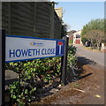
Ensbury Park: Howeth Close
A short cul-de-sac of maybe 1970s housing off the major side-road, Howeth Road.
The sign is a modern one, from 2010-15 when this more modern, abstract emblem rather than the traditional town coat of arms as the working logo of the council.
This is photo no.206 of a series of 453 in my coronavirus lockdown walking project:
See https://www.geograph.org.uk/article/My-2020-Coronavirus-Lockdown-walking-project for the complete set of photos.
Image: © Chris Downer
Taken: 11 Apr 2020
0.08 miles
9
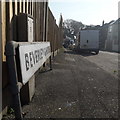
Ensbury Park: Beverley Gardens
The parked van allows us only a glimpse along this snaking no-through road, but that glimpse tells us that it consists of desirable detached houses and is not a modern cul-de-sac like many of the infill developments in the area.
The sign also tells us that the road isn't modern: it looks like an ordinary 1980s sign mounted on tubular steel (such as the one at Image), but careful scrutiny will tell us that the lettering and black border is embossed in the metalwork and not put on adhesively like the more modern variety. This makes it one of the older, perhaps 1960s, nameplates.
This is photo no.39 of a series of 451 in my coronavirus lockdown walking project:
See https://www.geograph.org.uk/article/My-2020-Coronavirus-Lockdown-walking-project for the complete set of photos.
Image: © Chris Downer
Taken: 11 Apr 2020
0.08 miles
10
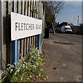
Northbourne: Fletcher Road
A short east-west road linking Howeth Road and Green Lane, used occasionally as a sort of cut-through – only occasionally because this is one of those areas where none of the roads goes fully between any of the major roads so you have to keep doing a left-right, and it would possibly have been just as quick therefore to stick to the bigger roads in the first place!
The sign is of a design that became prevalent in Bournemouth around 1990 and was in use for most of that decade. Many are starting to look a bit shabby now, and the blue border has faded to nothing on this one.
This is photo no.145 of a series of 453 in my coronavirus lockdown walking project:
See https://www.geograph.org.uk/article/My-2020-Coronavirus-Lockdown-walking-project for the complete set of photos.
Image: © Chris Downer
Taken: 11 Apr 2020
0.09 miles