IMAGES TAKEN NEAR TO
Hadow Road, BOURNEMOUTH, BH10 5HS
Introduction
This page details the photographs taken nearby to Hadow Road, BH10 5HS by members of the Geograph project.
The Geograph project started in 2005 with the aim of publishing, organising and preserving representative images for every square kilometre of Great Britain, Ireland and the Isle of Man.

There are currently over 7.5m images from over14,400 individuals and you can help contribute to the project by visiting https://www.geograph.org.uk
Image Map
Images are licensed for reuse under creativecommons.org/licenses/by-sa/2.0
Notes
- Clicking on the map will re-center to the selected point.
- The higher the marker number, the further away the image location is from the centre of the postcode.
Image Listing (79 Images Found)
Images are licensed for reuse under creativecommons.org/licenses/by-sa/2.0
Image
Details
Distance
1
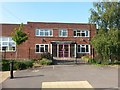
East Howe: original main entrance of The Bourne Academy
A contrasting view to Image - the new main entrance, replacing this one, has changed the appearance of the school, as the visitor approaches it, beyond all recognition. The 1930s origins of the school are all the more evident here.
Image: © Chris Downer
Taken: 7 Jun 2016
0.02 miles
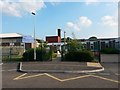
2
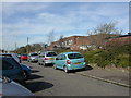
East Howe, high school
Kings High School, (formerly Kingsleigh Secondary School), on Hadow Road. The road seems also to function as staff car park. http://www.kingshigh.bournemouth.sch.uk/
Image: © Mike Faherty
Taken: 1 Mar 2010
0.03 miles
3
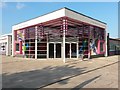
East Howe: The Bourne Academy main entrance
A bright, modern, snazzy entrance to a secondary school that has recently increased in popularity and in size, including the introduction of a sixth form in 2015. The entrance here belies the 1930s origins of the school - originally Kingsleigh Secondary School - which is more evident if we look at the original main entrance further along its frontage: Image
On the opposite side of Hadow Road, directly facing the Academy, is Image
Image: © Chris Downer
Taken: 7 Jun 2016
0.05 miles
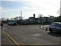
4
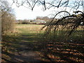
East Howe, open space
Public open space between Image and Green Lane.
Image: © Mike Faherty
Taken: 1 Mar 2010
0.05 miles
5
East Howe: Kingsleigh Primary School
Hadow Road provides education right through from nursery to sixth form, with The Bourne Academy (secondary school) behind us, and Kingsleigh Primary School here, including pre-school.
Originally this was Kingsleigh Junior, with Kingsleigh First next to the secondary school, then called Kingsleigh Secondary. The first school site was demolished around the time that it merged with the juniors to form an all-through primary school, in the early 2000s.
Kingsleigh Primary has undergone vast expansion in the last few years, increasing its intake to 120 (four classes) as part of the provision of extra school places - thanks to a large birth-rate increase across Bournemouth. Part of the new-build is seen in the left-hand half of the picture.
The youth centre, just across Kinson Road a few hundred yards from here, is dated 1911 in the gable and was the original East Howe School, the predecessor of the Kingsleighs.
Image: © Chris Downer
Taken: 7 Jun 2016
0.06 miles
6
East Howe, primary school
Kingsleigh Primary School & Nursery, on Hadow Road. See also Image http://www.goldhilleducation.com/calendar/jsp/indexpages/kingsleighindex.jsp?schoolName=Kingsleigh
Image: © Mike Faherty
Taken: 1 Mar 2010
0.06 miles
7
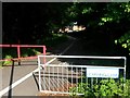
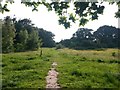
East Howe: Learning Lane from Hadow Road
Public footpath U39 has, in recent years, been marked out as a shared foot/cycle route. We see it here from its western end at the dead end of Hadow Road - it leads to Green Lane and then on to Heather Road.
Many of the footpaths on the West Howe estate and thereabouts have been given names in the last couple of years, a safety initiative whose intention is that, in the event of calling for help, one's location can be more easily described. This one has been named Learning Lane, no doubt because it leads to Hadow Road, where the area's primary and secondary schools are located (Image and Image).
See Image for the view along this segment of the path from Green Lane, and links to further pictures along the route.
Image: © Chris Downer
Taken: 7 Jun 2016
0.08 miles
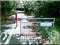
9
East Howe: public green space by Hadow Road
A meadowy area between the dead-ends of Hadow Road (ahead of us) and Green Lane (just behind us: Image)
Image: © Chris Downer
Taken: 7 Jun 2016
0.09 miles
10
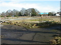
East Howe, school site
On Hadow Road, once the site of Kingsleigh Primary School (Leigh Site), before that, Kingsleigh First School. The current primary school is across the road.
Image: © Mike Faherty
Taken: 1 Mar 2010
0.10 miles