IMAGES TAKEN NEAR TO
Howeth Road, BOURNEMOUTH, BH10 5EA
Introduction
This page details the photographs taken nearby to Howeth Road, BH10 5EA by members of the Geograph project.
The Geograph project started in 2005 with the aim of publishing, organising and preserving representative images for every square kilometre of Great Britain, Ireland and the Isle of Man.

There are currently over 7.5m images from over14,400 individuals and you can help contribute to the project by visiting https://www.geograph.org.uk
Image Map
Images are licensed for reuse under creativecommons.org/licenses/by-sa/2.0
Notes
- Clicking on the map will re-center to the selected point.
- The higher the marker number, the further away the image location is from the centre of the postcode.
Image Listing (146 Images Found)
Images are licensed for reuse under creativecommons.org/licenses/by-sa/2.0
Image
Details
Distance
1
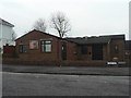
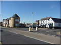
Ensbury Park: Howeth Road Evangelical Church
Situated on the staggered crossroads of Howeth and Kingswell Roads.
Image: © Chris Downer
Taken: 24 Feb 2008
0.03 miles
2
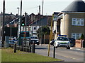
Bournemouth : Columbia Road
A police car on Columbia Road, and some traffic lights near a bus stop.
Image: © Lewis Clarke
Taken: 8 Mar 2010
0.07 miles
3
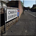
Ensbury Park: Charles Gardens
An early- or mid-1980s development off Kingswell Road, eating into the surrounding back gardens – an early forerunner of the much similar infill development that has occurred hereabouts in recent years.
The sign is the standard Bournemouth nameplate from the 1980s, affixed with tubular steel which protrudes at each side. For cul-de-sacs, it is common for these to incorporate the no-through road sign, as here.
This is photo no.67 of a series of 453 in my coronavirus lockdown walking project:
See https://www.geograph.org.uk/article/My-2020-Coronavirus-Lockdown-walking-project for the complete set of photos.
Image: © Chris Downer
Taken: 13 Apr 2020
0.07 miles
4
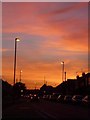
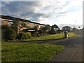
Ensbury Park: a vivid orange sky over Columbia Road
Looking west along Columbia Road towards the end of tonight's sunset, one of the vividest that I can recall.
Image: © Chris Downer
Taken: 11 Sep 2009
0.07 miles
5
Bournemouth : Columbia Road & Road Junctions
Two roads lead off here from Columbia Road - Glenville Road and Howeth Road.
Image: © Lewis Clarke
Taken: 8 Mar 2010
0.07 miles
6
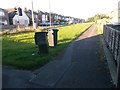
Ensbury Park: footpath N35 from its western end
This public footpath is essentially a frontage path for a line of even numbers 142-162 Columbia Road, separated from the carriageway by a grass patch.
We see it here extending from a more major footpath, N08, which heads towards Slades Farm to our right. See Image for the view towards us from across the road (left), and Image for another view of footpath N35, from the far end.
Image: © Chris Downer
Taken: 3 Jul 2016
0.08 miles
7
Ensbury Park: footpath N08 leaves Columbia Road
A long public footpath, varying in characteristics, is seen here at its northern end, between a large detached house and a council terrace.
This is the more urban end of the path - it runs through the Slades Farm estate, then across a large recreation ground before abutting woods to arrive at Boundary Road. At 1195 metres in length, it is one of the longest public rights of way in Bournemouth.
See Image for the next view along the path, and links to further pictures along its entire length.
(Also partly in shot is another footpath, numbered N35, running along the frontages of the houses to the left - see Image)
Image: © Chris Downer
Taken: 3 Jul 2016
0.08 miles
8
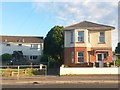
Ensbury Park
This is the junction of Howeth Rd , Columbia Rd and Glenville Avenue as viewed from Howeth Rd. The detached houses are on Columbia Rd the east-west route through Ensbury Park.
Image: © Nigel Mykura
Taken: 23 Apr 2011
0.08 miles
9
Ensbury Park: footpath N35 from its eastern end
This public footpath is essentially a frontage path for a line of even numbers 142-162 Columbia Road, separated from the carriageway by a grass patch.
We see it here extending from the actual pavement of Columbia Road; it ends by the detached house in the background, on footpath N08 which heads left.
See Image for a view of the footpath from the other end, and Image for a wider view of this end.
Image: © Chris Downer
Taken: 3 Jul 2016
0.08 miles
10
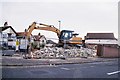
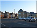
Make way for more flats
This site, on the corner of Columbia, Howeth and Glenville Roads, has been occupied by a boarded up old bakery and a perfectly good adjoining house for many years. Along with most disused sites in Bournemouth and Poole (not to mention many perfectly good houses!), it is being redeveloped as blocks of flats.
They are everywhere!
Image: © Chris Downer
Taken: 23 Jun 2007
0.08 miles