IMAGES TAKEN NEAR TO
Talbot Village, BOURNEMOUTH, BH10 4JA
Introduction
This page details the photographs taken nearby to Talbot Village, BH10 4JA by members of the Geograph project.
The Geograph project started in 2005 with the aim of publishing, organising and preserving representative images for every square kilometre of Great Britain, Ireland and the Isle of Man.

There are currently over 7.5m images from over14,400 individuals and you can help contribute to the project by visiting https://www.geograph.org.uk
Image Map
Images are licensed for reuse under creativecommons.org/licenses/by-sa/2.0
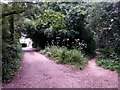
Notes
- Clicking on the map will re-center to the selected point.
- The higher the marker number, the further away the image location is from the centre of the postcode.
Image Listing (163 Images Found)
Images are licensed for reuse under creativecommons.org/licenses/by-sa/2.0
Image
Details
Distance
1
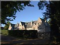
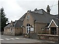
Almshouses,Talbot Village
A view of Image, which links to the listed building description, seen from a lane past some of the village's cottages.
Image: © Derek Harper
Taken: 12 Oct 2009
0.00 miles
2
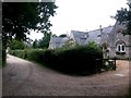
Talbot Village: footpath N15 passes the almshouses
The estate track forms public footpath N15 and we see it here as it passes some historic almshouses, next door to the school (whose bell-tower can be seen in the distance).
See Image for the next photo along the path ahead, and Image for the next view on the path behind us. Each has further links to photos along all mentioned routes.
Image: © Chris Downer
Taken: 9 Jul 2016
0.01 miles
3
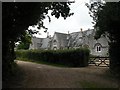
Talbot Village: almshouses
These almshouses are in the woody, historical part of Talbot Village, and maintain their privacy by way of a substantial hedge.
Image: © Chris Downer
Taken: 6 Jul 2008
0.01 miles
4
Talbot Village, almshouses
English Heritage-listed almshouses built by Georgina Talbot in 1862 as part of her model village Image Could accommodate 14 people in 7 units; each had a pig sty & poultry run. Coal, doctor's fees, an allowance, building upkeep and burial expenses were paid for. At my visit, I couldn't detect pigs or poultry! http://www.imagesofengland.org.uk/Details/Default.aspx?id=101887&mode=adv
Image: © Mike Faherty
Taken: 4 Jan 2009
0.01 miles
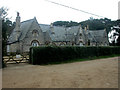
5
Talbot Village: St. Mark?s School from the north
Another view of Image, showing the bell tower.
Image: © Chris Downer
Taken: 6 Jul 2008
0.02 miles
6
Talbot Village: it looks like a roundabout on footpath N16
This public footpath, coming up on the left and continuing ahead, reaches a four-way path junction (the other two directions are not designated as public rights of way). At the centre of the junction is a small bush which makes the arrangement look rather like a roundabout. You do not have to go round it clockwise, though.
See Image for the next view along footpath N16 to the left, and Image for the view of its convergence with one of the estate tracks, ahead. These links contain further links to pictures along the routes.
Image: © Chris Downer
Taken: 9 Jul 2016
0.02 miles
7
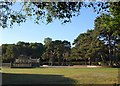
Playground, Talbot Village
The playground contains some of the few modern structures in the model village, the rest of which dates from the mid C19 (see Image).
Image: © Derek Harper
Taken: 12 Oct 2009
0.03 miles
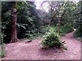
8
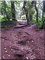
Talbot Village: footpath N16 is a route of roots
This stretch of the public footpath crosses several tree roots as it heads through the woods of Talbot Village.
See Image for the next view along the path ahead, and Image for the next view behind us.
Image: © Chris Downer
Taken: 9 Jul 2016
0.03 miles
9
Talbot Village: footpath N16 joins footpath N15
Looking along the track forming public footpath N15 as it turns a bend towards the school. Meanwhile, a smaller public footpath, number N16, emerges from the woods to the right.
See:
Image for the next view along path N15, left;
Image for the next view behind us; and
Image for the next view along path N16, right.
Each link provides further links to photos along the route.
Image: © Chris Downer
Taken: 9 Jul 2016
0.03 miles
10
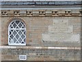
Talbot Village: St. Mark?s School ? foundation stones
Detail of the frontage of Image, intimating at the sisters after whom Talbot Village was named.
Image: © Chris Downer
Taken: 6 Jul 2008
0.03 miles