IMAGES TAKEN NEAR TO
Ensbury Close, BOURNEMOUTH, BH10 4HW
Introduction
This page details the photographs taken nearby to Ensbury Close, BH10 4HW by members of the Geograph project.
The Geograph project started in 2005 with the aim of publishing, organising and preserving representative images for every square kilometre of Great Britain, Ireland and the Isle of Man.

There are currently over 7.5m images from over14,400 individuals and you can help contribute to the project by visiting https://www.geograph.org.uk
Image Map
Images are licensed for reuse under creativecommons.org/licenses/by-sa/2.0
Notes
- Clicking on the map will re-center to the selected point.
- The higher the marker number, the further away the image location is from the centre of the postcode.
Image Listing (158 Images Found)
Images are licensed for reuse under creativecommons.org/licenses/by-sa/2.0
Image
Details
Distance
1
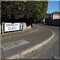
Ensbury Park: Ensbury Close
A 1980s (or maybe late 70s, when Ensbury Avenue was extended from about here into the new council estate) cul-de-sac off Ensbury Avenue. One of the addresses, perhaps the one pictured as it is a house rather than a bungalow, was the caretaker's house of the almost adjacent Glenmoor girls' secondary school.
The sign is the standard Bournemouth nameplate from the 1980s, affixed with tubular steel which protrudes at each side. For cul-de-sacs, it is common for these to incorporate the no-through road sign, as here.
This is photo no.134 of a series of 453 in my coronavirus lockdown walking project:
See https://www.geograph.org.uk/article/My-2020-Coronavirus-Lockdown-walking-project for the complete set of photos.
Image: © Chris Downer
Taken: 13 Apr 2020
0.03 miles
2
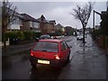
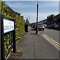
Bournemouth : Beswick Avenue
Beswick Avenue on a rainy day
Image: © Lewis Clarke
Taken: 18 Nov 2007
0.04 miles
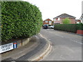
4
Ensbury Park: Glenmoor School
Situated at the southern end of Beswick Avenue, this is a large secondary school for girls: the boys' counterpart is now on the neighbouring site – see Image
Image: © Chris Downer
Taken: 6 Jul 2008
0.06 miles
5
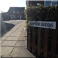
Ensbury Park: Glenmoor Gardens
A modern infill development behind Ensbury Avenue. The virtually unbroken line of houses is split into three in terms of address and access, with the more or less identical Hartmoor Gardens and Ensbury Gardens adjacent to the north.
The sign is small and nonstandard and, therefore, presumably erected by the developer rather than the council.
This is photo no.165 of a series of 453 in my coronavirus lockdown walking project:
See https://www.geograph.org.uk/article/My-2020-Coronavirus-Lockdown-walking-project for the complete set of photos.
Image: © Chris Downer
Taken: 13 Apr 2020
0.07 miles
6
Ensbury Park: Gorsecliff Road
A two-segment road of early 20th century detached houses, off what was then the minor Boundary Road. Since the early 1980s, when Boundary Road became the main A347 into Bournemouth, Gorsecliff Road has become a busy cut-through to miss the Ensbury Park Gyratory, as it is the first through road turn-off northbound, after Glenmoor school grounds.
As these houses were built before off-road parking was a consideration, it can get rather snarled up where someone queuing to pull out does so between parked cars, blocking the way for oncoming traffic.
It is easy to blame it on bravado or impatience – and it often is – but there are times when one just doesn't realise until it is too late to do anything about it.
The sign is a modern one, from 2010-15 when this more modern, abstract emblem rather than the traditional town coat of arms as the working logo of the council.
This is photo no.168 of a series of 453 in my coronavirus lockdown walking project:
See https://www.geograph.org.uk/article/My-2020-Coronavirus-Lockdown-walking-project for the complete set of photos.
Image: © Chris Downer
Taken: 19 Apr 2020
0.07 miles
7
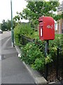
Ensbury Park: postbox № BH10 156, Ensbury Avenue
The pole on which this postbox stands is in the grounds of Talbot View, a nursing home.
Image: © Chris Downer
Taken: 6 Jul 2008
0.07 miles
9
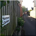
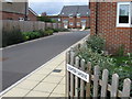
Ensbury Park: Hartmoor Gardens
A modern infill development behind Ensbury Avenue. The virtually unbroken line of houses is split into three in terms of address and access, with the more or less identical Glenmoor Gardens to the south and Ensbury Gardens to the north.
The sign is small and nonstandard and, therefore, presumably erected by the developer rather than the council.
This is photo no.181 of a series of 453 in my coronavirus lockdown walking project:
See https://www.geograph.org.uk/article/My-2020-Coronavirus-Lockdown-walking-project for the complete set of photos.
Image: © Chris Downer
Taken: 13 Apr 2020
0.08 miles
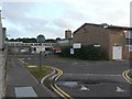
10
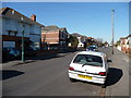
Bournemouth : Beswick Avenue
Beswick Avenue which leads towards Columbia Road.
Image: © Lewis Clarke
Taken: 8 Mar 2010
0.08 miles