IMAGES TAKEN NEAR TO
St. Margarets Road, BOURNEMOUTH, BH10 4BG
Introduction
This page details the photographs taken nearby to St. Margarets Road, BH10 4BG by members of the Geograph project.
The Geograph project started in 2005 with the aim of publishing, organising and preserving representative images for every square kilometre of Great Britain, Ireland and the Isle of Man.

There are currently over 7.5m images from over14,400 individuals and you can help contribute to the project by visiting https://www.geograph.org.uk
Image Map
Images are licensed for reuse under creativecommons.org/licenses/by-sa/2.0
Notes
- Clicking on the map will re-center to the selected point.
- The higher the marker number, the further away the image location is from the centre of the postcode.
Image Listing (108 Images Found)
Images are licensed for reuse under creativecommons.org/licenses/by-sa/2.0
Image
Details
Distance
1
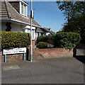
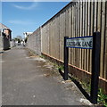
Ensbury Park: Columbia Trees Lane
This rather rurally named road runs between St. Margaret's Road and Talbot Rise, and has dwellings on only one side: they face the allotments which are on our right. It consists of bungalows, as is the norm for all the roads in the vicinity.
The sign is of a design that became prevalent in Bournemouth around 1990 and was in use for most of that decade. Many are starting to look a bit shabby now, but this one is in good condition without any peeling white or fading blue.
The additional arrow is because this is a 90º turn in the carriageway, rather than a junction as such. St. Margaret's Road that is to our left, with no other roads to right or behind.
This is photo no.78 of a series of 453 in my coronavirus lockdown walking project:
See https://www.geograph.org.uk/article/My-2020-Coronavirus-Lockdown-walking-project for the complete set of photos.
Image: © Chris Downer
Taken: 15 Apr 2020
0.02 miles
2

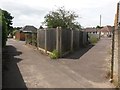
Ensbury Park: southern end of Furze Bank Lane
We look towards the southern end of Furze Bank Lane, which is formed of three segments, each a public footpath. This southern segment is N04, the middle segment N05, and the northern segment N07.
Here, we see garage access off the lane, with a post preventing motor vehicles from proceeding any further towards us.
See Image for a view along the path from the end ahead, and Image for the next view behind us, with links to further photos along the whole course of the lane.
Image: © Chris Downer
Taken: 9 Jul 2016
0.06 miles
3

Ensbury Park: Furze Bank Lane from Columbia Trees Lane
Looking along this lane - more of a path, really - from its southern end. Furze Bank Lane is formed of three segments, each a public footpath. Footpath N04 starts here, the middle segment is footpath N05, and the northern segment is N07.
See Image for the view towards us from the post visible ahead, and links to further photos along the whole length of the path.
Image: © Chris Downer
Taken: 9 Jul 2016
0.06 miles
4

Ensbury Park: passing the one house in Furze Bank Lane
This is the southern of three segments of Furze Bank Lane - each is a public footpath. This segment is footpath N04, and the other two are N05 and N07.
Here, we look south past the entrance to number 1, not actually the only property on the lane, but the only one with the lane as its address.
The railings are positioned here, partway along the path, of course because the house has a driveway access.
See Image for the next view along the path ahead, and Image for the next view behind us (with further links to photos all along the path).
Image: © Chris Downer
Taken: 9 Jul 2016
0.06 miles
5
Ensbury Park: Furze Bank Lane crosses Nicholas Gardens
We stand on the middle of three segments of Furze Bank Lane - each is a public footpath. The southern segment (ahead) is N04, this middle segment N05, and the northern segment N07.
The very recent sign spells Furze Bank as one word, Furzebank.
See: Image for the next view along the path ahead, and Image for the next view behind us (explaining what happened to the number N06).
Image: © Chris Downer
Taken: 9 Jul 2016
0.07 miles
6
Ensbury Park: footpath N06 joins Furze Bank Lane
We stand on the middle of three segments of Furze Bank Lane - each is a public footpath. The southern segment is N04, this middle segment N05, and the northern segment N07.
Here, we see an offshoot of it, footpath N06 (right), cutting a corner from Nicholas Gardens. An electricity substation stands in the intervening triangle.
See:
Image for the next view along Furze Bank Lane, ahead-left;
Image for the next view along the lane behind us; and
Image for a view along path N06 (ahead-right) from the far end.
Image: © Chris Downer
Taken: 9 Jul 2016
0.07 miles
7

Ensbury Park: footpath N06 from Nicholas Gardens
This public footpath is a very short one - we can clearly see the end ahead. It forms a short cut to Furze Bank Lane, which crosses Nicholas Gardens just past the tree.
An electricity substation is positioned at the far corner of the intervening triangle.
See Image for a view along the path from the far end, including links to further photos along Furze Bank Lane in both directions.
Image: © Chris Downer
Taken: 9 Jul 2016
0.08 miles
8
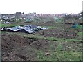
Ensbury Park: allotments
A large area of allotments off Priestley Road. A housing development is under construction near the entrance, visible in the distance.
Image: © Chris Downer
Taken: 3 Feb 2008
0.08 miles
9
Ensbury Park: Furzebank Lane
A broad public footpath in three segments, this being the middle one viewed from Nicholas Gardens towards Cove Road. Royal Mail still gives the name as three words, Furze Bank Lane, like previous signage while the current A-Z agrees with the sign here.
See Image for links to further photos along the lane in each direction.
The sign is a modern one, dating from around 2014-15, by which time the council had replaced the coloured logo, which had been prone to fading after a while, to simple wording BOURNEMOUTH BOROUGH COUNCIL in smaller type.
This is photo no.154 of a series of 453 in my coronavirus lockdown walking project:
See https://www.geograph.org.uk/article/My-2020-Coronavirus-Lockdown-walking-project for the complete set of photos.
Image: © Chris Downer
Taken: 14 Apr 2020
0.08 miles
10
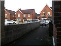
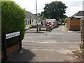
Wallisdown: footpath N01 comes out opposite some newish houses
This short public footpath, from Acton Road, originally came out here on Priestley Road opposite a large plot of allotments. About 10 years ago, these houses were built on Priestley Road and the row behind forming Cornelia Road. The allotments still exist behind the houses, though, and it is still quite a large plot.
The chimney breast of the bungalow on the right has a minor architectural exuberance, with two rows of bricks stepped outwards slightly on the way up.
See Image for the view towards us from the road ahead, and Image for the next view on the path behind us.
Image: © Chris Downer
Taken: 2 Mar 2017
0.09 miles