IMAGES TAKEN NEAR TO
Wallis Road, BOURNEMOUTH, BH10 4AG
Introduction
This page details the photographs taken nearby to Wallis Road, BH10 4AG by members of the Geograph project.
The Geograph project started in 2005 with the aim of publishing, organising and preserving representative images for every square kilometre of Great Britain, Ireland and the Isle of Man.

There are currently over 7.5m images from over14,400 individuals and you can help contribute to the project by visiting https://www.geograph.org.uk
Image Map
Images are licensed for reuse under creativecommons.org/licenses/by-sa/2.0
Notes
- Clicking on the map will re-center to the selected point.
- The higher the marker number, the further away the image location is from the centre of the postcode.
Image Listing (72 Images Found)
Images are licensed for reuse under creativecommons.org/licenses/by-sa/2.0
Image
Details
Distance
1

Wallisdown: Norman Motors by night
After dark, the cars on the frontage of Norman Motors are floodlit strikingly with a pale bluish tint. This was also a filling station, among the cheapest in the area, until a couple of years ago.
Image: © Chris Downer
Taken: 10 Jul 2008
0.05 miles
2
Entrance to allotments, Wallisdown
These allotments are off Alton Road, and run along the rear of Priestley Road.
Image: © Derek Harper
Taken: 12 Oct 2009
0.06 miles
3
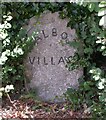
Talbot Village, White Stone
Local name for Talbot Village boundary stone, at the junction of Wallisdown & Alton Roads & marking the south-eastern corner of the village. Tombstone-shaped, simple lettering TALBOT (curving) / VILLAGE. Probably erected when the village was built, in the 1860s-70s.
Image: © Mike Faherty
Taken: 4 Jan 2009
0.07 miles
4
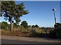
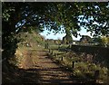
Wallisdown: footpath N10 from Alton Road
The track ahead forms the start of public footpath N10, to Talbot Village. It turns right just ahead to continue hugging the churchyard.
See Image for the view towards us, and further links to photos all along the footpath route.
Image: © Chris Downer
Taken: 9 Jul 2016
0.07 miles
6
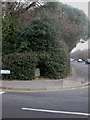
Old Boundary Marker by the A3049, Wallisdown Road
Estate Boundary Marker by the A3049, in parish of Bournemouth (Bournemouth District), Wallisdown Road junction with Alton Road, in hedge.
Inscription reads:-
TALBOT
VILLAGE
Carved bench mark on lower face.
Surveyed
Milestone Society National ID: HA_BMTAL01em
Image: © Milestone Society
Taken: Unknown
0.08 miles
7
Wallisdown: footpath N10 comes out on Alton Road
The public footpath has just done a 90° turn, around the corner of the churchyard, and now meets Alton Road just as it too does a 90° turn.
See Image for a view up the path from the road ahead, and Image] for the next view of the path behind us, with links to further photos on the route.
Image: © Chris Downer
Taken: 9 Jul 2016
0.08 miles
8
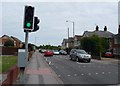
Bournemouth : Wallisdown Road & Road Crossing
Image: © Lewis Clarke
Taken: 20 May 2009
0.09 miles
9
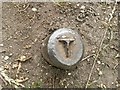
Wallisdown: I wonder what T stands for?
This little metal pole - or the remains of one, is set into the ground on the track from Alton Road, just by the corner of the churchyard.
It is about the width of a fencepost, four or five inches in diameter, and has a T inscribed in its top.
It occurs to me that it might just be a T-shaped extension that has been sawn off - a signpost or some such - but I'm not sure.
Image: © Chris Downer
Taken: 9 Jul 2016
0.10 miles
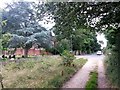
10
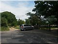
Track from Alton Road
A public footpath follows this track round to the right along the north side of Image
Image: © Derek Harper
Taken: 12 Oct 2009
0.10 miles