IMAGES TAKEN NEAR TO
Fewston Avenue, BRADFORD, BD6 3WF
Introduction
This page details the photographs taken nearby to Fewston Avenue, BD6 3WF by members of the Geograph project.
The Geograph project started in 2005 with the aim of publishing, organising and preserving representative images for every square kilometre of Great Britain, Ireland and the Isle of Man.

There are currently over 7.5m images from over14,400 individuals and you can help contribute to the project by visiting https://www.geograph.org.uk
Image Map
Images are licensed for reuse under creativecommons.org/licenses/by-sa/2.0
Notes
- Clicking on the map will re-center to the selected point.
- The higher the marker number, the further away the image location is from the centre of the postcode.
Image Listing (95 Images Found)
Images are licensed for reuse under creativecommons.org/licenses/by-sa/2.0
Image
Details
Distance
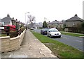
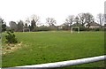
2
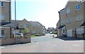
Fewston Avenue - off Yateholm Drive
Image: © Betty Longbottom
Taken: 22 May 2012
0.04 miles
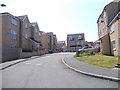
3
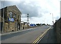
Cooper Lane, Great Horton
The B6147, linking the A647 with the A6036.
Image: © Humphrey Bolton
Taken: 19 Aug 2010
0.04 miles
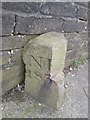
7
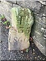
Old Boundary Marker on Cooper Lane, Clayton Heights
Municipal Boundary Marker against a stone wall on the B6147 Cooper Lane, Clayton Heights. On the boundary of North Bierley and Halifax Poor Law Unions. Inscribed N.B. (the B looks like I due to damage) / 183 (remainder lost due to damage) on one face and H. (the H looks like I due to damage) / (part lost due to damage) 35 / 1860 on the other. The top outer corner of the stone looks like it has been cut away. View also https://www.geograph.org.uk/photo/6475272.
Milestone Society National ID: YW_BRAD02pb
Image: © N Hewlett
Taken: 16 Nov 2022
0.05 miles
8
Old Boundary Marker on Cooper Lane, Clayton Heights
Municipal Boundary Marker against a stone wall on the B6147 Cooper Lane, Clayton Heights. On the boundary of North Bierley and Halifax Poor Law Unions. Inscribed N.B. (the B looks like I due to damage) / 183 (remainder lost due to damage) on one face and H. (the H looks like I due to damage) / (part lost due to damage) 35 / 1860 on the other. The top outer corner of the stone looks like it has been cut away. See also https://www.geograph.org.uk/photo/7343255.
Milestone Society National ID: YW_BRAD02pb
Image: © H Brown
Taken: 29 Mar 2017
0.05 miles
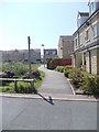
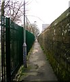
9
Yateholm Drive - viewed from Chelker Close
Image: © Betty Longbottom
Taken: 22 May 2012
0.06 miles