IMAGES TAKEN NEAR TO
Hastings Place, BRADFORD, BD5 9PE
Introduction
This page details the photographs taken nearby to Hastings Place, BD5 9PE by members of the Geograph project.
The Geograph project started in 2005 with the aim of publishing, organising and preserving representative images for every square kilometre of Great Britain, Ireland and the Isle of Man.

There are currently over 7.5m images from over14,400 individuals and you can help contribute to the project by visiting https://www.geograph.org.uk
Image Map (Loading...)


Getting Data...Please wait
Leaflet Map data © OpenStreetMap
Images are licensed for reuse under creativecommons.org/licenses/by-sa/2.0
Notes
- Clicking on the map will re-center to the selected point.
- The higher the marker number, the further away the image location is from the centre of the postcode.
Image Listing (165 Images Found)
Images are licensed for reuse under creativecommons.org/licenses/by-sa/2.0
Image
Details
Distance
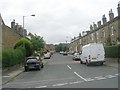

6
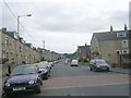
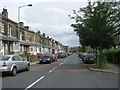
Marsh Street - looking towards Manchester Road
Image: © Betty Longbottom
Taken: 2 Aug 2011
0.06 miles
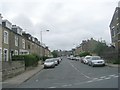
8
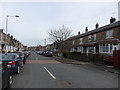
Hastings Avenue, Marshfields
This is the bottom half of the street, from Broadway Avenue down to Marsh Street. I bought my first house on here in 1979 for £10,500 and sold it 3 years later for £12,500.
Image: © Stephen Armstrong
Taken: 8 Apr 2018
0.07 miles
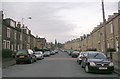
10
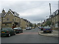
Hastings Avenue - Broadway Avenue
Image: © Betty Longbottom
Taken: 23 Jul 2011
0.07 miles