IMAGES TAKEN NEAR TO
Hetton Drive, BRADFORD, BD3 8RS
Introduction
This page details the photographs taken nearby to Hetton Drive, BD3 8RS by members of the Geograph project.
The Geograph project started in 2005 with the aim of publishing, organising and preserving representative images for every square kilometre of Great Britain, Ireland and the Isle of Man.

There are currently over 7.5m images from over14,400 individuals and you can help contribute to the project by visiting https://www.geograph.org.uk
Image Map
Images are licensed for reuse under creativecommons.org/licenses/by-sa/2.0
Notes
- Clicking on the map will re-center to the selected point.
- The higher the marker number, the further away the image location is from the centre of the postcode.
Image Listing (207 Images Found)
Images are licensed for reuse under creativecommons.org/licenses/by-sa/2.0
Image
Details
Distance
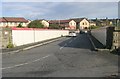
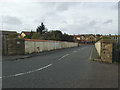
3
View from Bridge LBE1-37 - New Lane
Image: © Betty Longbottom
Taken: 16 Oct 2008
0.05 miles
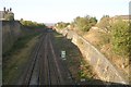
5
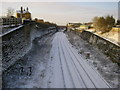
Leeds to Bradford Railway Line
Looking west from bridge LBE1/37, New Lane. This was the site of Laisterdyke Station & the station house can be seen perched high above the track. The other bridge is LBE2/39, A6177 Laisterdyke.
Image: © Stephen Armstrong
Taken: 3 Jan 2010
0.06 miles
6
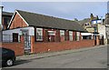
Sant Nirankari Satsang Bhawan - Napier Street
Image: © Betty Longbottom
Taken: 15 Sep 2007
0.06 miles
7
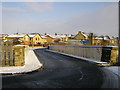
New Lane Bridge, Bradford
Bridge LBE1/37 over the Leeds to Bradford railway line. The parapets are quite high restricting visibility round the sharp corner for car drivers.
Image: © Stephen Armstrong
Taken: 3 Jan 2010
0.07 miles
8
Railway bridge on New Lane, Laisterdyke
Laisterdyke once boasted the Great Northern's railway station with four platforms (to the left of the bridge) and a complicated double-triangular junction with lines radiating to Bradford, Shipley, Leeds (by two routes), Wakefield, Dewsbury and Halifax. The station closed in 1966, most of the lines around the same time, and only the through route from Bradford to Leeds now remains, with no station. This bridge once for tracks in the station throat.
Image: © Stephen Craven
Taken: 5 Sep 2020
0.07 miles
9
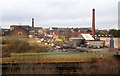
Ing Street, Laisterdyke
Mill chimneys and a former dairy, seen across the railway line from a hillock beside New Lane.
Image: © Derek Harper
Taken: 21 Dec 2012
0.07 miles