IMAGES TAKEN NEAR TO
Undercliffe Old Road, BRADFORD, BD2 4RQ
Introduction
This page details the photographs taken nearby to Undercliffe Old Road, BD2 4RQ by members of the Geograph project.
The Geograph project started in 2005 with the aim of publishing, organising and preserving representative images for every square kilometre of Great Britain, Ireland and the Isle of Man.

There are currently over 7.5m images from over14,400 individuals and you can help contribute to the project by visiting https://www.geograph.org.uk
Image Map
Images are licensed for reuse under creativecommons.org/licenses/by-sa/2.0
Notes
- Clicking on the map will re-center to the selected point.
- The higher the marker number, the further away the image location is from the centre of the postcode.
Image Listing (180 Images Found)
Images are licensed for reuse under creativecommons.org/licenses/by-sa/2.0
Image
Details
Distance
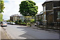
1
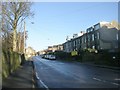
Undercliffe Old Road - viewed from Westfield Crescent
Image: © Betty Longbottom
Taken: 18 Jan 2011
0.04 miles
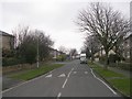
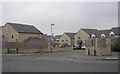
2
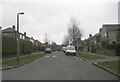
Barmby Road - Undercliffe Old Road
Image: © Betty Longbottom
Taken: 28 Feb 2009
0.04 miles
3
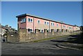
Undercliffe Health Care Centre
This is a narrow wing, seen from Barmby Road. The main block is behind, off Lowther Street.
Image: © Humphrey Bolton
Taken: 3 Feb 2011
0.04 miles
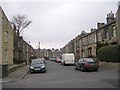
4
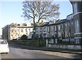
Westfield Crescent - Undercliffe Old Road
Image: © Betty Longbottom
Taken: 18 Jan 2011
0.05 miles
8
Undercliffe Old Road - Undercliffe Lane
Image: © Betty Longbottom
Taken: 28 Feb 2009
0.05 miles
9
Primary Way - Undercliffe Old Road
Image: © Betty Longbottom
Taken: 28 Feb 2009
0.05 miles
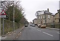
10
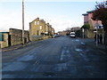
Undercliffe Old Road near its junction with Barmby Road
Looking northward.
Image: © Peter Wood
Taken: 31 Dec 2017
0.06 miles