IMAGES TAKEN NEAR TO
Foston Lane, BRADFORD, BD2 3QB
Introduction
This page details the photographs taken nearby to Foston Lane, BD2 3QB by members of the Geograph project.
The Geograph project started in 2005 with the aim of publishing, organising and preserving representative images for every square kilometre of Great Britain, Ireland and the Isle of Man.

There are currently over 7.5m images from over14,400 individuals and you can help contribute to the project by visiting https://www.geograph.org.uk
Image Map (Loading...)


Getting Data...Please wait
Leaflet Map data © OpenStreetMap
Images are licensed for reuse under creativecommons.org/licenses/by-sa/2.0
Notes
- Clicking on the map will re-center to the selected point.
- The higher the marker number, the further away the image location is from the centre of the postcode.
Image Listing (49 Images Found)
Images are licensed for reuse under creativecommons.org/licenses/by-sa/2.0
Image
Details
Distance
1
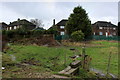
Path across Fagley Beck
Party of a muddy footpath between Fagley and Woodhall Lane, where the build up of rubbish and general fly tipping is a disgrace and possibly a health hazard.
Image: © Chris Heaton
Taken: 12 Jan 2016
0.03 miles
3
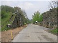
Disused railway bridge, Woodhall Road, Calverley
The railway was the LNER Shipley Branch.
Image: © Humphrey Bolton
Taken: 3 Feb 2011
0.10 miles
4
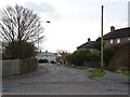
Footpath - Woodhall Road to Stone Stile
Image: © Betty Longbottom
Taken: 5 May 2008
0.10 miles
5
Remains of Bridge on Dismantled Railway - Woodhall Road
The line opened in 1874, ran from Shipley to Laisterdyke Junction, via Thackley, Idle and Eccleshill. The line closed to passenger traffic in 1931, was then made single track and continued as a goods line until 1968.
Image: © Betty Longbottom
Taken: 5 May 2008
0.10 miles
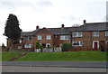
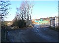
8
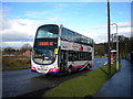
Bus leaving Fagley terminus, Bradford
On the eastern fringe of Bradford, one of First West Yorkshire's Volvo B9TL/Wright Eclipse Gemini double deckers departs the terminal stop in Fagley at the beginning of its journey to Buttershaw via Bradford city centre. Just behind the bus, the road widens out to provide a turning area for buses before the housing stops and the road narrows to little more than a track.
Image: © Richard Vince
Taken: 26 Feb 2011
0.12 miles
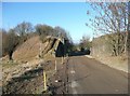
9
Quarry entrance, Woodhall Road, Calverley
This seems to be a re-opening of Woodhall Quarries further to the north-east. These were shown on the 1930s six-inch map as disused. Woodhall Road continues towards the Blue Pig (pub), which can be seen in the distance, but curves round to the right, becoming Fagley Road.
Image: © Humphrey Bolton
Taken: 3 Feb 2011
0.13 miles
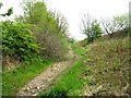
10
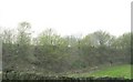
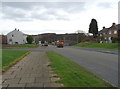
Embankment of Dismantled Railway - Woodhall Road
Image: © Betty Longbottom
Taken: 5 May 2008
0.13 miles