IMAGES TAKEN NEAR TO
Whitehead Place, BRADFORD, BD2 3NL
Introduction
This page details the photographs taken nearby to Whitehead Place, BD2 3NL by members of the Geograph project.
The Geograph project started in 2005 with the aim of publishing, organising and preserving representative images for every square kilometre of Great Britain, Ireland and the Isle of Man.

There are currently over 7.5m images from over14,400 individuals and you can help contribute to the project by visiting https://www.geograph.org.uk
Image Map
Images are licensed for reuse under creativecommons.org/licenses/by-sa/2.0
Notes
- Clicking on the map will re-center to the selected point.
- The higher the marker number, the further away the image location is from the centre of the postcode.
Image Listing (114 Images Found)
Images are licensed for reuse under creativecommons.org/licenses/by-sa/2.0
Image
Details
Distance
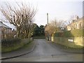
3
Intake Grove - looking towards Intake Road
Image: © Betty Longbottom
Taken: 13 Dec 2010
0.04 miles
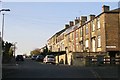
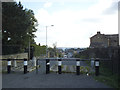
5
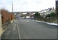
Intake Road
Looking down towards the Fagley Road Junction. The bollards are, presumably, to stop motorists using it as a "Rat Run" between Killinghall Road (the Bradford Ring Road), and the A647 Leeds to Bradford Road via Gain Lane.
Image: © Stephen Armstrong
Taken: 23 Aug 2010
0.06 miles

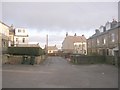
9
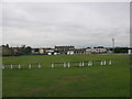
Undercliffe Cricket Club
Taken over the wall from Intake Road.
Image: © Stephen Armstrong
Taken: 23 Aug 2010
0.07 miles
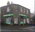
10
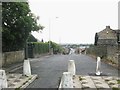
Summit of Intake Road
This point is the southern end of a ridge that runs south from Eccleshill at about 210m altitude, effectively the watershed between Bradford and Leeds. The view is east-south-east. An extra line of "defences" has been added to the traffic barrier since Stephen Armstrong's 2010 photo Image
Image: © Stephen Craven
Taken: 19 Sep 2015
0.07 miles