IMAGES TAKEN NEAR TO
Hazlewood, SKIPTON, BD23 6JL
Introduction
This page details the photographs taken nearby to BD23 6JL by members of the Geograph project.
The Geograph project started in 2005 with the aim of publishing, organising and preserving representative images for every square kilometre of Great Britain, Ireland and the Isle of Man.

There are currently over 7.5m images from over14,400 individuals and you can help contribute to the project by visiting https://www.geograph.org.uk
Image Map
Images are licensed for reuse under creativecommons.org/licenses/by-sa/2.0
Notes
- Clicking on the map will re-center to the selected point.
- The higher the marker number, the further away the image location is from the centre of the postcode.
Image Listing (17 Images Found)
Images are licensed for reuse under creativecommons.org/licenses/by-sa/2.0
Image
Details
Distance
2
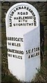
Old Milestone by the former A59, Summerscales
Metal plate attached to stone post by the UC road (was A59), in parish of HAZLEWOOD WITH STORITHS (CRAVEN District), Summerscales, on the verge at eastern end of old section of road, on North side of road. West Riding iron casting, erected by the County Council in the 19th century.
Inscription reads:-
: HARROGATE / 14 MILES / KNARESBORO / 16¾ MILES : : SKIPTON & KNARESBOROUGH / ROAD / HAZELWOOD / WITH / STORRITHS : : SKIPTON / 8 MILES :
Yorkshire Dales National Park Authority Listed.
https://www.heritagegateway.org.uk/Gateway/Results_Single.aspx?uid=2125285&resourceID=420
Milestone Society National ID: YN_SKKB08.
Image: © C Minto
Taken: 16 May 2004
0.04 miles
3
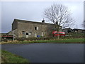
Summerscales Farm
On a loop of the old Skipton & Knaresborough Road at Summerscales.
Image: © David Rogers
Taken: 5 Mar 2009
0.04 miles
4
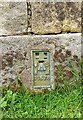
Summerscales Farm House
Flush bracket 11578, surveyors mark on the old farmhouse. Located on the old Bolton Abbey/Blubberhouses road, now bypassed by faster 3-lane A59.
Image: © Mel Towler
Taken: 28 May 2021
0.05 miles
5
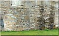
Summerscales Farm House
Wider angle of the farm house, with the surveyor's flush bracket, 11578. Located just to the left of the stoned-up archway, and at ground level.
Image: © Mel Towler
Taken: 28 May 2021
0.05 miles
6
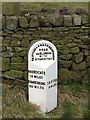
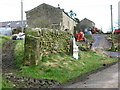
Milestone by the old A59
The stone was once by the Skipton to Knaresborough turnpike, which later became the A59. Now marooned on one of the loops of old road.
Image: © Gordon Hatton
Taken: 23 Feb 2009
0.06 miles
7
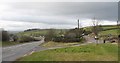
Old and new roads
Looking downhill along the A59 [left], with the old road to the right. This section leading east from Bolton Bridge used to be a winding and tortuous ascent, but the road was re-engineered in the 1970's. Still a hazardous road with sections of three lane, whilst North Yorkshire Police are often here waiting for speeders.
Image: © Gordon Hatton
Taken: 23 Feb 2009
0.08 miles
8
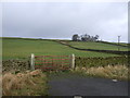
Field entrance near Summerscales Farm
Off the A59.
Image: © JThomas
Taken: 10 Dec 2016
0.09 miles
9
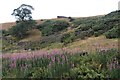
Scrubby slopes and field wall at Summerscales
Image: © Alan Reid
Taken: 16 Jul 2018
0.17 miles
10
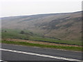
A59 and valley near Blubberhouses
Looking across the A59 to the valley of Kex Gill with the low crags of High Combs beyond.
Image: © liz dawson
Taken: 13 Apr 2007
0.17 miles