IMAGES TAKEN NEAR TO
Kilnsey, SKIPTON, BD23 5PS
Introduction
This page details the photographs taken nearby to BD23 5PS by members of the Geograph project.
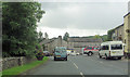
The Geograph project started in 2005 with the aim of publishing, organising and preserving representative images for every square kilometre of Great Britain, Ireland and the Isle of Man.

There are currently over 7.5m images from over14,400 individuals and you can help contribute to the project by visiting https://www.geograph.org.uk
Image Map
Images are licensed for reuse under creativecommons.org/licenses/by-sa/2.0
Notes
- Clicking on the map will re-center to the selected point.
- The higher the marker number, the further away the image location is from the centre of the postcode.
Image Listing (77 Images Found)
Images are licensed for reuse under creativecommons.org/licenses/by-sa/2.0
Image
Details
Distance
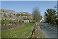
1
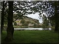
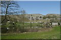
Kilnsey village across one of the fishing lakes at Kilnsey Park
Image: © Chris Holifield
Taken: 2 Oct 2020
0.01 miles
2
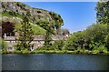
Kilnsey
Cottages and fishing lake at Kilnsey with Kilnsey Crag in the background.
Image: © Peter McDermott
Taken: 17 May 2014
0.01 miles
3
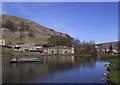
View of Kilnsey Crag
Taken from the Trout Farm looking across the lake.
Image: © Lynne Glazzard
Taken: 12 Apr 2003
0.01 miles
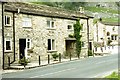
4
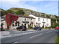
The Tennant Arms
The Tennant Arms in the village of Kilnsey in the Yorkshire Dales.
Image: © Paul Bridge
Taken: 23 Sep 2007
0.02 miles
5
Lake and Kilnsey Crag
Looking along the road beside Kilnsey Park.
Image: © DS Pugh
Taken: 30 Mar 2021
0.02 miles
6
Kilnsey in Wharfedale
The Tennant Arms under Kilnsey Crag, to the right, and two cottages, the left one of which was the base for walking part of the Dales' Way in 1994.
Image: © M J Richardson
Taken: Unknown
0.03 miles
7
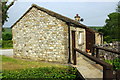
Bungalow on east side of B6160
There is an OS benchmark Image on the near corner of the house left of the black downpipe.
Image: © Roger Templeman
Taken: 18 Jun 2013
0.03 miles
8
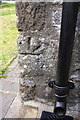
Inverted benchmark on bungalow on E side of B6160
Ordnance Survey cut mark benchmark described on the Bench Mark Database at http://www.bench-marks.org.uk/bm49070. The stone with the mark was probably turned upside down when the building was rebuilt during conversion from brewhouse for the pub opposite to the present bungalow
Image: © Roger Templeman
Taken: 18 Jun 2013
0.03 miles
10
Fishing at Kilnsey Park
Looking across a fishing lake from the road.
Image: © DS Pugh
Taken: 30 Mar 2021
0.05 miles