IMAGES TAKEN NEAR TO
Bridge End, SKIPTON, BD23 5NH
Introduction
This page details the photographs taken nearby to Bridge End, BD23 5NH by members of the Geograph project.
The Geograph project started in 2005 with the aim of publishing, organising and preserving representative images for every square kilometre of Great Britain, Ireland and the Isle of Man.

There are currently over 7.5m images from over14,400 individuals and you can help contribute to the project by visiting https://www.geograph.org.uk
Image Map
Images are licensed for reuse under creativecommons.org/licenses/by-sa/2.0
Notes
- Clicking on the map will re-center to the selected point.
- The higher the marker number, the further away the image location is from the centre of the postcode.
Image Listing (264 Images Found)
Images are licensed for reuse under creativecommons.org/licenses/by-sa/2.0
Image
Details
Distance
1
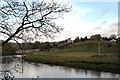
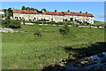
Grassington: Bridge End Cottages
This row of twelve cottages were photographed from the opposite bank of the River Wharfe. They are numbered consecutively from 1 at the far end. The larger building partially visible further right is a GP surgery.
Image: © Dr Neil Clifton
Taken: 2 Nov 2014
0.00 miles
2
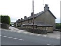
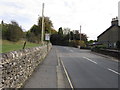
Terrace off Station Road, Grassington
Looking across Station Road at a terrace of stone built houses.
Image: © Graham Robson
Taken: 7 Aug 2015
0.00 miles
4
![Grassington features [6]](https://s1.geograph.org.uk/geophotos/07/03/85/7038565_6a08fee3_120x120.jpg)
Grassington features [6]
This County Bridge Marker is seen on the south side of Station Road, B6265. The marker indicates the extent of roadway adjoining the bridge that the County was obliged to maintain.
Grassington is a small market town, receiving its charter in 1282. The town is located in Wharfedale in the Yorkshire Dales National Park, some 7½ miles north of Skipton. Lead mining brought prosperity to the town in the 18th and 19th centuries. The town now attracts many tourists, especially walkers, with some excellent routes on the surrounding fells.
Image: © Michael Dibb
Taken: 26 Jun 2021
0.02 miles
6
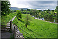
Footpath beside the River Wharfe
This path is part of the Dales Way.
Image: © Rob Burke
Taken: 11 May 2011
0.02 miles
7
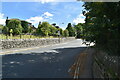
The Dales Way
#231, Station Road, Grassington.
Image: © Ian S
Taken: 19 Oct 2012
0.02 miles
8
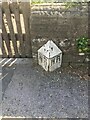
County Bridge Marker on the B6265, Grassington
County Bridge Marker against a stone garden wall on the south side of the B6265 Station Road east of Grassington Bridge, River Wharfe. Grassington parish. The casting marks the extent of roadway adjoining the bridge that the County was obliged to maintain.
Milestone Society National ID: YW_GRASS07br
Image: © P Robertson
Taken: 3 Aug 2021
0.03 miles
9
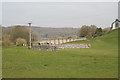
Grassington: View towards bridge over R. Wharfe
Image: © Dr Neil Clifton
Taken: 9 Apr 2017
0.04 miles
10
![Grassington features [5]](https://s2.geograph.org.uk/geophotos/07/03/85/7038562_4e2c9c73_120x120.jpg)
Grassington features [5]
The River Wharfe, looking downstream from Grassington Bridge which carries Station Road, B6265.
Grassington is a small market town, receiving its charter in 1282. The town is located in Wharfedale in the Yorkshire Dales National Park, some 7½ miles north of Skipton. Lead mining brought prosperity to the town in the 18th and 19th centuries. The town now attracts many tourists, especially walkers, with some excellent routes on the surrounding fells.
Image: © Michael Dibb
Taken: 26 Jun 2021
0.05 miles